Kandara geodata
Kandara (Murang'A) is a populated place; located in Kenya in Africa/Nairobi (GMT+3) time zone. With population of 914 people, there are 110 cities with bigger population in this country. Compared to other cities in Kenya, 64.9% of cities are located further ↑North; 60.5% of cities are located further ←West and 62.3% of cities have lower elevation than Kandara. Note1


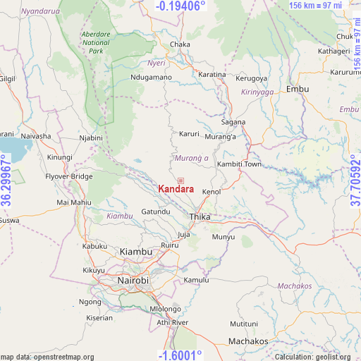
Kandara GPS coordinates[2]
0° 53' 49.74" South, 37° 0' 10.044" East
| Map corner | latitude | longitude |
|---|---|---|
| Upper-left | -0.19406°, | 36.29967° |
| Center: | -0.89715°, | 37.00279° |
| Lower-right: | -1.6001°, | 37.70592° |
| Map W x H: | 156.3×156.3 km | = 97.1×97.1mi |
| max Lat: | 3.93726° ⇑64.9% North |
| Kandara: | -0.89715° |
| min Lat: | ⇓35.1% South -4.64756° |
| min Long | Kandara | max Long |
| 33.97248° | 37.00279° | 41.85688° |
| W 60.5%⇐ | ⇒39.5% E |
Elevation
Elevation of Kandara is 1629 m = 5344 ft, and this is 282.3 m = 926 ft above average elevation for this country.
| Max E: |
2514 m = 8248 ft | 37.7% |
| Kandara | 1629 m 5344 ft | |
| Avg. | 1346.7 m = 4418 ft | |
Min E: |
7 m = 23 ft | 62.3% |
See also: Kenya elevation on elevation.city.
Geographical zone
Kandara is located in South Torrid zone (between Equator and Tropic of Capricorn). Distance of Equator is 99.8 km =62 mi to North.| Distance of | km | miles | from Kandara |
|---|---|---|---|
| Equator | 99.8 | 62 | to North |
| Tropic Capricorn | 2506.2 | 1557.3 | to South |
| Antarctic Circle | 7301.4 | 4536.9 | to South |
| South Pole | 9907.3 | 6156.1 | to South |


Nearby cities:
15 places around Kandara: (largest is in red/bold)
• Kangema
23.9 km =14.9 mi,  349°
349°
• Karuri
29.7 km =18.5 mi,  42°
42°
• Kerugoya
54 km =33.6 mi,  34°
34°
• Kiambu
35.7 km =22.2 mi,  211°
211°
• Kijabe
48 km =29.8 mi,  265°
265°
• Kikuyu
54.2 km =33.7 mi,  224°
224°
• Limuru
46.8 km =29.1 mi,  239°
239°
• Maragua
18.3 km =11.4 mi,  52°
52°
• Murang’a
25.7 km =16 mi, 40°
• Nairobi
47.7 km =29.6 mi, 205°
• Nyeri
53.4 km =33.2 mi, 353°
• Othaya
39.8 km =24.7 mi, 348°
• Pumwani
46.2 km =28.7 mi,  201°
201°
• Sagana
34.3 km =21.3 mi, 41°
• Thika
16.8 km =10.4 mi,  153°
153°
Sources, notices
• [Note1] Compared only with cities in Kenya existing in our database
• [Src1] Map data: © OpenStreetMap contributors (CC-BY-SA)
• [Src2] Other city data from geonames.org with taken over terms of usage.
• [Src3] Geographical zone / Annual Mean Temperature by Robert A. Rohde @ Wikipedia
