Nairobi geodata
Nairobi (Nairobi Area) is a capital of a political entity; located in Kenya in Africa/Nairobi (GMT+3) time zone. With population of 2,750,547 people, there are 0 cities with bigger population in this country. Compared to other cities in Kenya, 74.6% of cities are located further ↑North; 54.4% of cities are located further ←West and 66.7% of cities have lower elevation than Nairobi. Note1


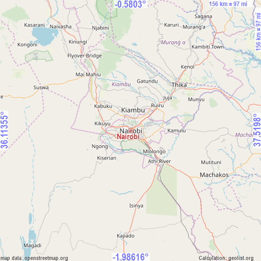
Nairobi GPS coordinates[2]
1° 16' 59.988" South, 36° 49' 0.012" East
| Map corner | latitude | longitude |
|---|---|---|
| Upper-left | -0.5803°, | 36.11355° |
| Center: | -1.28333°, | 36.81667° |
| Lower-right: | -1.98616°, | 37.5198° |
| Map W x H: | 156.3×156.3 km | = 97.1×97.1mi |
| max Lat: | 3.93726° ⇑74.6% North |
| Nairobi: | -1.28333° |
| min Lat: | ⇓25.4% South -4.64756° |
| min Long | Nairobi | max Long |
| 33.97248° | 36.81667° | 41.85688° |
| W 54.4%⇐ | ⇒45.6% E |
Elevation
Elevation of Nairobi is 1684 m = 5525 ft, and this is 337.3 m = 1107 ft above average elevation for this country.
| Max E: |
2514 m = 8248 ft | 33.3% |
| Nairobi | 1684 m 5525 ft | |
| Avg. | 1346.7 m = 4418 ft | |
Min E: |
7 m = 23 ft | 66.7% |
See also: Nairobi elevation on elevation.city.
Geographical zone
Nairobi is located in South Torrid zone (between Equator and Tropic of Capricorn). Distance of Equator is 142.7 km =88.7 mi to North.| Distance of | km | miles | from Nairobi |
|---|---|---|---|
| Equator | 142.7 | 88.7 | to North |
| Tropic Capricorn | 2463.2 | 1530.6 | to South |
| Antarctic Circle | 7258.5 | 4510.2 | to South |
| South Pole | 9864.4 | 6129.5 | to South |


Nearby cities:
15 places around Nairobi: (largest is in red/bold)
• Athi River
26.3 km =16.3 mi,  136°
136°
• Kajiado
63.4 km =39.4 mi,  184°
184°
• Kandara
47.7 km =29.6 mi,  25°
25°
• Kangema
68.5 km =42.6 mi,  13°
13°
• Kangundo
59.1 km =36.7 mi,  92°
92°
• Kiambu
12.6 km =7.8 mi, 9°
• Kijabe
47.5 km =29.5 mi,  325°
325°
• Kikuyu
17.6 km =10.9 mi,  283°
283°
• Konza
61.6 km =38.3 mi,  145°
145°
• Limuru
27.1 km =16.8 mi,  314°
314°
• Machakos
56.5 km =35.1 mi,  118°
118°
• Maragua
64.6 km =40.1 mi, 32°
• Ngong
18 km =11.2 mi,  244°
244°
• Pumwani
3.7 km =2.3 mi, 90°
• Thika
39.5 km =24.5 mi,  45°
45°
Sources, notices
• [Note1] Compared only with cities in Kenya existing in our database
• [Src1] Map data: © OpenStreetMap contributors (CC-BY-SA)
• [Src2] Other city data from geonames.org with taken over terms of usage.
• [Src3] Geographical zone / Annual Mean Temperature by Robert A. Rohde @ Wikipedia
