Maragua geodata
Maragua (Murang'A) is a populated place; located in Kenya in Africa/Nairobi (GMT+3) time zone. With population of 4,661 people, there are 89 cities with bigger population in this country. Compared to other cities in Kenya, 63.2% of cities are located further ↑North; 64.9% of cities are located further ←West and 56.1% of cities have higher elevation than Maragua. Note1


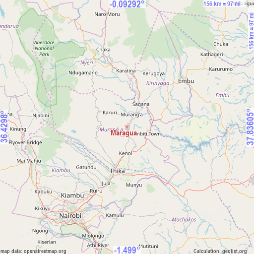
Maragua GPS coordinates[2]
0° 47' 45.672" South, 37° 7' 58.512" East
| Map corner | latitude | longitude |
|---|---|---|
| Upper-left | -0.09292°, | 36.4298° |
| Center: | -0.79602°, | 37.13292° |
| Lower-right: | -1.499°, | 37.83605° |
| Map W x H: | 156.3×156.3 km | = 97.1×97.1mi |
| max Lat: | 3.93726° ⇑63.2% North |
| Maragua: | -0.79602° |
| min Lat: | ⇓36.8% South -4.64756° |
| min Long | Maragua | max Long |
| 33.97248° | 37.13292° | 41.85688° |
| W 64.9%⇐ | ⇒35.1% E |
Elevation
Elevation of Maragua is 1360 m = 4462 ft, and this is 13.3 m = 44 ft above average elevation for this country.
| Max E: |
2514 m = 8248 ft | 56.1% |
| Maragua | 1360 m 4462 ft | |
| Avg. | 1346.7 m = 4418 ft | |
Min E: |
7 m = 23 ft | 43.9% |
See also: Kenya elevation on elevation.city.
Geographical zone
Maragua is located in South Torrid zone (between Equator and Tropic of Capricorn). Distance of Equator is 88.5 km =55 mi to North.| Distance of | km | miles | from Maragua |
|---|---|---|---|
| Equator | 88.5 | 55 | to North |
| Tropic Capricorn | 2517.4 | 1564.2 | to South |
| Antarctic Circle | 7312.7 | 4543.9 | to South |
| South Pole | 9918.6 | 6163.1 | to South |


Nearby cities:
15 places around Maragua: (largest is in red/bold)
• Embu
46 km =28.6 mi,  51°
51°
• Kandara
18.3 km =11.4 mi,  232°
232°
• Kangema
22.4 km =13.9 mi,  303°
303°
• Kangundo
61.3 km =38.1 mi,  157°
157°
• Karuri
12.1 km =7.5 mi,  27°
27°
• Kerugoya
36.9 km =22.9 mi, 26°
• Kiambu
53.2 km =33.1 mi,  218°
218°
• Kijabe
64.2 km =39.9 mi,  256°
256°
• Murang’a
8.6 km =5.3 mi,  14°
14°
• Nairobi
64.6 km =40.1 mi,  212°
212°
• Nyeri
46.6 km =29 mi,  333°
333°
• Othaya
35.6 km =22.1 mi,  321°
321°
• Pumwani
62.7 km =39 mi, 210°
• Sagana
16.5 km =10.3 mi, 30°
• Thika
27.3 km =17 mi,  195°
195°
Sources, notices
• [Note1] Compared only with cities in Kenya existing in our database
• [Src1] Map data: © OpenStreetMap contributors (CC-BY-SA)
• [Src2] Other city data from geonames.org with taken over terms of usage.
• [Src3] Geographical zone / Annual Mean Temperature by Robert A. Rohde @ Wikipedia
