Kijabe geodata
Kijabe (Nakuru) is a populated place; located in Kenya in Africa/Nairobi (GMT+3) time zone. With population of 4,679 people, there are 88 cities with bigger population in this country. Compared to other cities in Kenya, 65.8% of cities are located further ↑North; 50.9% of cities are located further →East and 91.2% of cities have lower elevation than Kijabe. Note1


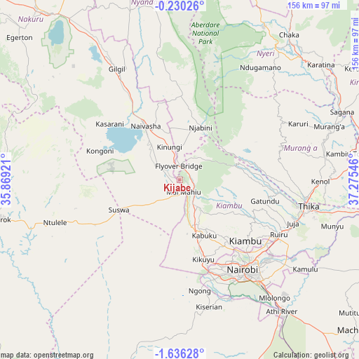
Kijabe GPS coordinates[2]
0° 56' 0.024" South, 36° 34' 20.388" East
| Map corner | latitude | longitude |
|---|---|---|
| Upper-left | -0.23026°, | 35.86921° |
| Center: | -0.93334°, | 36.57233° |
| Lower-right: | -1.63628°, | 37.27546° |
| Map W x H: | 156.3×156.3 km | = 97.1×97.1mi |
| max Lat: | 3.93726° ⇑65.8% North |
| Kijabe: | -0.93334° |
| min Lat: | ⇓34.2% South -4.64756° |
| min Long | Kijabe | max Long |
| 33.97248° | 36.57233° | 41.85688° |
| W 49.1%⇐ | ⇒50.9% E |
Elevation
Elevation of Kijabe is 2050 m = 6726 ft, and this is 703.3 m = 2307 ft above average elevation for this country.
| Max E: |
2514 m = 8248 ft | 8.8% |
| Kijabe | 2050 m 6726 ft | |
| Avg. | 1346.7 m = 4418 ft | |
Min E: |
7 m = 23 ft | 91.2% |
See also: Kenya elevation on elevation.city.
Geographical zone
Kijabe is located in South Torrid zone (between Equator and Tropic of Capricorn). Distance of Equator is 103.8 km =64.5 mi to North.| Distance of | km | miles | from Kijabe |
|---|---|---|---|
| Equator | 103.8 | 64.5 | to North |
| Tropic Capricorn | 2502.1 | 1554.7 | to South |
| Antarctic Circle | 7297.4 | 4534.4 | to South |
| South Pole | 9903.3 | 6153.6 | to South |


Nearby cities:
15 places around Kijabe: (largest is in red/bold)
• Kandara
48 km =29.8 mi,  85°
85°
• Kangema
51.6 km =32.1 mi,  57°
57°
• Karuri
72.7 km =45.2 mi,  69°
69°
• Kiambu
39.5 km =24.5 mi,  132°
132°
• Kikuyu
36.2 km =22.5 mi,  163°
163°
• Limuru
21.5 km =13.4 mi, 158°
• Maragua
64.2 km =39.9 mi,  76°
76°
• Murang’a
68.7 km =42.7 mi, 69°
• Nairobi
47.5 km =29.5 mi,  145°
145°
• Naivasha
28.9 km =18 mi,  327°
327°
• Ngong
47.9 km =29.8 mi,  166°
166°
• Nyeri
70.7 km =43.9 mi,  36°
36°
• Othaya
58.7 km =36.5 mi, 42°
• Pumwani
49.7 km =30.9 mi,  141°
141°
• Thika
56.4 km =35 mi,  101°
101°
Sources, notices
• [Note1] Compared only with cities in Kenya existing in our database
• [Src1] Map data: © OpenStreetMap contributors (CC-BY-SA)
• [Src2] Other city data from geonames.org with taken over terms of usage.
• [Src3] Geographical zone / Annual Mean Temperature by Robert A. Rohde @ Wikipedia
