Limuru geodata
Limuru (Kiambu) is a populated place; located in Kenya in Africa/Nairobi (GMT+3) time zone. With population of 6,317 people, there are 80 cities with bigger population in this country. Compared to other cities in Kenya, 70.2% of cities are located further ↑North; 50% of cities are located further ←West and 95.6% of cities have lower elevation than Limuru. Note1


Limuru GPS coordinates[2]
1° 6' 48.96" South, 36° 38' 31.38" East
| Map corner | latitude | longitude |
|---|---|---|
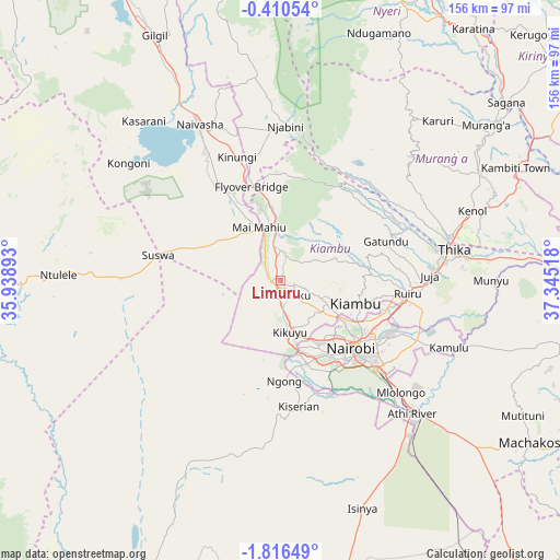
| Upper-left | -0.41054°, | 35.93893° |
| Center: | -1.1136°, | 36.64205° |
| Lower-right: | -1.81649°, | 37.34518° |
| Map W x H: | 156.3×156.3 km | = 97.1×97.1mi |
| max Lat: | 3.93726° ⇑70.2% North |
| Limuru: | -1.1136° |
| min Lat: | ⇓29.8% South -4.64756° |
| min Long | Limuru | max Long |
| 33.97248° | 36.64205° | 41.85688° |
| W 50%⇐ | ⇒50% E |
Elevation
Elevation of Limuru is 2248 m = 7375 ft, and this is 901.3 m = 2957 ft above average elevation for this country.
| Max E: |
2514 m = 8248 ft | 4.4% |
| Limuru | 2248 m 7375 ft | |
| Avg. | 1346.7 m = 4418 ft | |
Min E: |
7 m = 23 ft | 95.6% |
See also: Kenya elevation on elevation.city.
Geographical zone
Limuru is located in South Torrid zone (between Equator and Tropic of Capricorn). Distance of Equator is 123.8 km =76.9 mi to North.| Distance of | km | miles | from Limuru |
|---|---|---|---|
| Equator | 123.8 | 76.9 | to North |
| Tropic Capricorn | 2482.1 | 1542.3 | to South |
| Antarctic Circle | 7277.4 | 4522 | to South |
| South Pole | 9883.2 | 6141.1 | to South |


Nearby cities:
15 places around Limuru: (largest is in red/bold)
• Athi River
53.4 km =33.2 mi,  135°
135°
• Kandara
46.8 km =29.1 mi,  59°
59°
• Kangema
59.6 km =37 mi,  36°
36°
• Karuri
75.7 km =47 mi,  52°
52°
• Kiambu
22.5 km =14 mi,  106°
106°
• Kijabe
21.5 km =13.4 mi,  338°
338°
• Kikuyu
14.9 km =9.3 mi,  171°
171°
• Maragua
65 km =40.4 mi, 57°
• Murang’a
71.6 km =44.5 mi, 52°
• Nairobi
27.1 km =16.8 mi,  134°
134°
• Naivasha
50.2 km =31.2 mi,  332°
332°
• Ngong
26.8 km =16.7 mi, 173°
• Othaya
70.8 km =44 mi,  27°
27°
• Pumwani
29.8 km =18.5 mi, 129°
• Thika
48.3 km =30 mi,  79°
79°
Sources, notices
• [Note1] Compared only with cities in Kenya existing in our database
• [Src1] Map data: © OpenStreetMap contributors (CC-BY-SA)
• [Src2] Other city data from geonames.org with taken over terms of usage.
• [Src3] Geographical zone / Annual Mean Temperature by Robert A. Rohde @ Wikipedia
