Kangema geodata
Kangema (Murang'A) is a populated place; located in Kenya in Africa/Nairobi (GMT+3) time zone. With population of 4,319 people, there are 92 cities with bigger population in this country. Compared to other cities in Kenya, 57% of cities are located further ↑North; 58.8% of cities are located further ←West and 70.2% of cities have lower elevation than Kangema. Note1


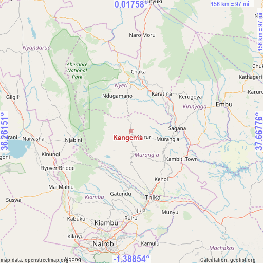
Kangema GPS coordinates[2]
0° 41' 7.908" South, 36° 57' 52.668" East
| Map corner | latitude | longitude |
|---|---|---|
| Upper-left | 0.01758°, | 36.26151° |
| Center: | -0.68553°, | 36.96463° |
| Lower-right: | -1.38854°, | 37.66776° |
| Map W x H: | 156.3×156.3 km | = 97.1×97.1mi |
| max Lat: | 3.93726° ⇑57% North |
| Kangema: | -0.68553° |
| min Lat: | ⇓43% South -4.64756° |
| min Long | Kangema | max Long |
| 33.97248° | 36.96463° | 41.85688° |
| W 58.8%⇐ | ⇒41.2% E |
Elevation
Elevation of Kangema is 1770 m = 5807 ft, and this is 423.3 m = 1389 ft above average elevation for this country.
| Max E: |
2514 m = 8248 ft | 29.8% |
| Kangema | 1770 m 5807 ft | |
| Avg. | 1346.7 m = 4418 ft | |
Min E: |
7 m = 23 ft | 70.2% |
See also: Kenya elevation on elevation.city.
Geographical zone
Kangema is located in South Torrid zone (between Equator and Tropic of Capricorn). Distance of Equator is 76.2 km =47.3 mi to North.| Distance of | km | miles | from Kangema |
|---|---|---|---|
| Equator | 76.2 | 47.3 | to North |
| Tropic Capricorn | 2529.7 | 1571.9 | to South |
| Antarctic Circle | 7325 | 4551.5 | to South |
| South Pole | 9930.8 | 6170.7 | to South |


Nearby cities:
15 places around Kangema: (largest is in red/bold)
• Embu
57.1 km =35.5 mi,  73°
73°
• Kandara
23.9 km =14.9 mi,  169°
169°
• Karuri
24.4 km =15.2 mi,  93°
93°
• Kerugoya
40.8 km =25.4 mi,  59°
59°
• Kiambu
55.9 km =34.7 mi,  194°
194°
• Kijabe
51.6 km =32.1 mi,  237°
237°
• Limuru
59.6 km =37 mi,  216°
216°
• Maragua
22.4 km =13.9 mi,  123°
123°
• Murang’a
21.3 km =13.2 mi,  100°
100°
• Naivasha
59.2 km =36.8 mi,  266°
266°
• Naro Moru
58.3 km =36.2 mi,  5°
5°
• Nyeri
29.6 km =18.4 mi,  356°
356°
• Othaya
15.9 km =9.9 mi,  346°
346°
• Sagana
27.2 km =16.9 mi, 85°
• Thika
40.4 km =25.1 mi,  163°
163°
Sources, notices
• [Note1] Compared only with cities in Kenya existing in our database
• [Src1] Map data: © OpenStreetMap contributors (CC-BY-SA)
• [Src2] Other city data from geonames.org with taken over terms of usage.
• [Src3] Geographical zone / Annual Mean Temperature by Robert A. Rohde @ Wikipedia
