Naivasha geodata
Naivasha (Nakuru) is a populated place; located in Kenya in Africa/Nairobi (GMT+3) time zone. With population of 38,366 people, there are 23 cities with bigger population in this country. Compared to other cities in Kenya, 59.6% of cities are located further ↑North; 52.6% of cities are located further →East and 93% of cities have lower elevation than Naivasha. Note1


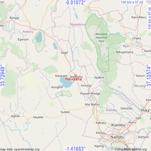
Naivasha GPS coordinates[2]
0° 42' 49.788" South, 36° 25' 57.396" East
| Map corner | latitude | longitude |
|---|---|---|
| Upper-left | -0.01072°, | 35.72949° |
| Center: | -0.71383°, | 36.43261° |
| Lower-right: | -1.41683°, | 37.13574° |
| Map W x H: | 156.3×156.3 km | = 97.1×97.1mi |
| max Lat: | 3.93726° ⇑59.6% North |
| Naivasha: | -0.71383° |
| min Lat: | ⇓40.4% South -4.64756° |
| min Long | Naivasha | max Long |
| 33.97248° | 36.43261° | 41.85688° |
| W 47.4%⇐ | ⇒52.6% E |
Elevation
Elevation of Naivasha is 2084 m = 6837 ft, and this is 737.3 m = 2419 ft above average elevation for this country.
| Max E: |
2514 m = 8248 ft | 7% |
| Naivasha | 2084 m 6837 ft | |
| Avg. | 1346.7 m = 4418 ft | |
Min E: |
7 m = 23 ft | 93% |
See also: Kenya elevation on elevation.city.
Geographical zone
Naivasha is located in South Torrid zone (between Equator and Tropic of Capricorn). Distance of Equator is 79.4 km =49.3 mi to North.| Distance of | km | miles | from Naivasha |
|---|---|---|---|
| Equator | 79.4 | 49.3 | to North |
| Tropic Capricorn | 2526.5 | 1569.9 | to South |
| Antarctic Circle | 7321.8 | 4549.6 | to South |
| South Pole | 9927.7 | 6168.8 | to South |


Nearby cities:
15 places around Naivasha: (largest is in red/bold)
• Kandara
66.6 km =41.4 mi,  107°
107°
• Kangema
59.2 km =36.8 mi,  86°
86°
• Kiambu
67.8 km =42.1 mi,  138°
138°
• Kijabe
28.9 km =18 mi,  147°
147°
• Kikuyu
64.5 km =40.1 mi,  156°
156°
• Limuru
50.2 km =31.2 mi, 152°
• Maragua
78.4 km =48.7 mi,  96°
96°
• Nairobi
76.4 km =47.5 mi, 146°
• Nakuru
60.4 km =37.5 mi,  318°
318°
• Narok
74.6 km =46.4 mi,  236°
236°
• Ngong
75.8 km =47.1 mi, 159°
• Nyeri
65.9 km =40.9 mi,  60°
60°
• Ol Kalou
49.6 km =30.8 mi,  353°
353°
• Othaya
58.5 km =36.4 mi,  71°
71°
• Pumwani
78.5 km =48.8 mi, 143°
Sources, notices
• [Note1] Compared only with cities in Kenya existing in our database
• [Src1] Map data: © OpenStreetMap contributors (CC-BY-SA)
• [Src2] Other city data from geonames.org with taken over terms of usage.
• [Src3] Geographical zone / Annual Mean Temperature by Robert A. Rohde @ Wikipedia
