Kapsabet geodata
Kapsabet (Nandi) is a seat of a first-order administrative division; located in Kenya in Africa/Nairobi (GMT+3) time zone. With population of 3,758 people, there are 98 cities with bigger population in this country. Compared to other cities in Kenya, 73.7% of cities are located further ↓South; 74.6% of cities are located further →East and 82.5% of cities have lower elevation than Kapsabet. Note1


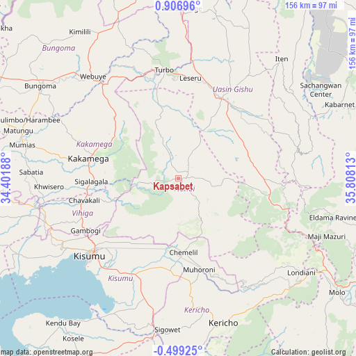
Kapsabet GPS coordinates[2]
0° 12' 13.932" North, 35° 6' 18" East
| Map corner | latitude | longitude |
|---|---|---|
| Upper-left | 0.90696°, | 34.40188° |
| Center: | 0.20387°, | 35.105° |
| Lower-right: | -0.49925°, | 35.80813° |
| Map W x H: | 156.4×156.4 km | = 97.2×97.2mi |
| max Lat: | 3.93726° ⇑26.3% North |
| Kapsabet: | 0.20387° |
| min Lat: | ⇓73.7% South -4.64756° |
| min Long | Kapsabet | max Long |
| 33.97248° | 35.105° | 41.85688° |
| W 25.4%⇐ | ⇒74.6% E |
Elevation
Elevation of Kapsabet is 1998 m = 6555 ft, and this is 651.3 m = 2137 ft above average elevation for this country.
| Max E: |
2514 m = 8248 ft | 17.5% |
| Kapsabet | 1998 m 6555 ft | |
| Avg. | 1346.7 m = 4418 ft | |
Min E: |
7 m = 23 ft | 82.5% |
See also: Kenya elevation on elevation.city.
Geographical zone
Kapsabet is located in North Torrid zone (between Equator and Tropic of Cancer). Distance of Equator is 22.7 km =14.1 mi to South.| Distance of | km | miles | from Kapsabet |
|---|---|---|---|
| North Pole | 9984.4 | 6204 | to North |
| Arctic Circle | 7378.5 | 4584.8 | to North |
| Tropic Cancer | 2583.3 | 1605.2 | to North |
| Equator | 22.7 | 14.1 | to South |


Nearby cities:
15 places around Kapsabet: (largest is in red/bold)
• Ahero
46.8 km =29.1 mi,  206°
206°
• Butere
68.4 km =42.5 mi,  270°
270°
• Eldoret
39.7 km =24.7 mi,  27°
27°
• Iten
68.5 km =42.6 mi,  40°
40°
• Kakamega
40.2 km =25 mi,  282°
282°
• Kericho
66.6 km =41.4 mi,  162°
162°
• Kipkelion
60.3 km =37.5 mi,  138°
138°
• Kisumu
51.1 km =31.8 mi,  228°
228°
• Londiani
68.1 km =42.3 mi,  127°
127°
• Mbale
44.7 km =27.8 mi,  252°
252°
• Muhoroni
41.5 km =25.8 mi,  165°
165°
• Mumias
70.1 km =43.6 mi, 281°
• Nandi Hills
14.2 km =8.8 mi, 141°
• Webuye
57.6 km =35.8 mi,  319°
319°
• Yala
64.4 km =40 mi,  259°
259°
Sources, notices
• [Note1] Compared only with cities in Kenya existing in our database
• [Src1] Map data: © OpenStreetMap contributors (CC-BY-SA)
• [Src2] Other city data from geonames.org with taken over terms of usage.
• [Src3] Geographical zone / Annual Mean Temperature by Robert A. Rohde @ Wikipedia
