Kathwana geodata
Kathwana (Tharaka - Nithi) is a seat of a first-order administrative division; located in Kenya in Africa/Nairobi (GMT+3) time zone. In our database, there are 111 cities with bigger population. Compared to other cities in Kenya, 55.3% of cities are located further ↓South; 77.2% of cities are located further ←West and 82.5% of cities have higher elevation than Kathwana. Note1


Kathwana GPS coordinates[2]
0° 19' 53.004" South, 37° 52' 6.996" East
| Map corner | latitude | longitude |
|---|---|---|
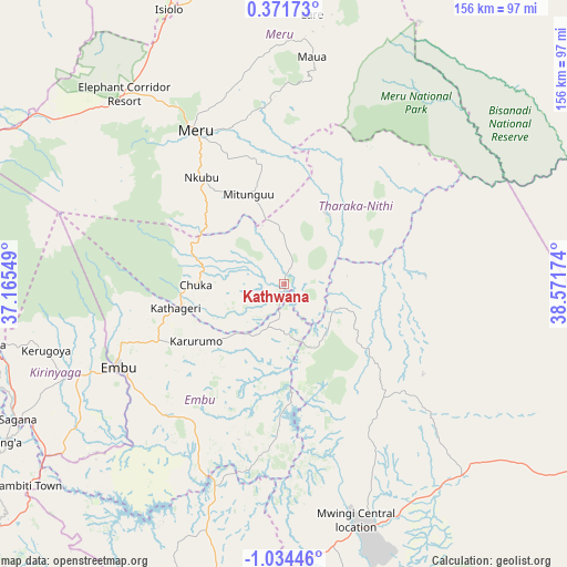
| Upper-left | 0.37173°, | 37.16549° |
| Center: | -0.33139°, | 37.86861° |
| Lower-right: | -1.03446°, | 38.57174° |
| Map W x H: | 156.4×156.4 km | = 97.2×97.2mi |
| max Lat: | 3.93726° ⇑44.7% North |
| Kathwana: | -0.33139° |
| min Lat: | ⇓55.3% South -4.64756° |
| min Long | Kathwana | max Long |
| 33.97248° | 37.86861° | 41.85688° |
| W 77.2%⇐ | ⇒22.8% E |
Elevation
Elevation of Kathwana is 722 m = 2369 ft, and this is 624.7 m = 2050 ft below average elevation for this country.
| Max E: |
2514 m = 8248 ft | 82.5% |
| Avg. | 1346.7 m = 4418 ft | |
| Kathwana | 722 m = 2369 ft | |
Min E: |
7 m = 23 ft | 17.5% |
See also: Kenya elevation on elevation.city.
Geographical zone
Kathwana is located in South Torrid zone (between Equator and Tropic of Capricorn). Distance of Equator is 36.8 km =22.9 mi to North.| Distance of | km | miles | from Kathwana |
|---|---|---|---|
| Equator | 36.8 | 22.9 | to North |
| Tropic Capricorn | 2569.1 | 1596.4 | to South |
| Antarctic Circle | 7364.3 | 4576 | to South |
| South Pole | 9970.2 | 6195.2 | to South |


Nearby cities:
15 places around Kathwana: (largest is in red/bold)
• Chuka
24.8 km =15.4 mi,  269°
269°
• Embu
51.3 km =31.9 mi,  243°
243°
• Isiolo
82.7 km =51.4 mi,  337°
337°
• Karuri
86.5 km =53.7 mi, 241°
• Kerugoya
68 km =42.3 mi,  254°
254°
• Maragua
96.7 km =60.1 mi, 237°
• Maua
63.3 km =39.3 mi,  7°
7°
• Meru
48.2 km =30 mi,  330°
330°
• Murang’a
90.6 km =56.3 mi, 241°
• Mwingi
70.5 km =43.8 mi,  162°
162°
• Nanyuki
96 km =59.7 mi,  293°
293°
• Naro Moru
96.4 km =59.9 mi,  281°
281°
• Nyeri
102.9 km =63.9 mi,  264°
264°
• Othaya
106.9 km =66.4 mi, 257°
• Sagana
82.4 km =51.2 mi, 242°
Sources, notices
• [Note1] Compared only with cities in Kenya existing in our database
• [Src1] Map data: © OpenStreetMap contributors (CC-BY-SA)
• [Src2] Other city data from geonames.org with taken over terms of usage.
• [Src3] Geographical zone / Annual Mean Temperature by Robert A. Rohde @ Wikipedia
