Busia geodata
Busia is a seat of a first-order administrative division; located in Kenya in Africa/Nairobi (GMT+3) time zone. With population of 51,981 people, there are 12 cities with bigger population in this country. Compared to other cities in Kenya, 83.3% of cities are located further ↓South; 97.4% of cities are located further →East and 64% of cities have higher elevation than Busia. Note1


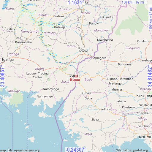
Busia GPS coordinates[2]
0° 27' 36.18" North, 34° 6' 42.084" East
| Map corner | latitude | longitude |
|---|---|---|
| Upper-left | 1.1631°, | 33.40857° |
| Center: | 0.46005°, | 34.11169° |
| Lower-right: | -0.24307°, | 34.81482° |
| Map W x H: | 156.4×156.4 km | = 97.2×97.2mi |
| max Lat: | 3.93726° ⇑16.7% North |
| Busia: | 0.46005° |
| min Lat: | ⇓83.3% South -4.64756° |
| min Long | Busia | max Long |
| 33.97248° | 34.11169° | 41.85688° |
| W 2.6%⇐ | ⇒97.4% E |
Elevation
Elevation of Busia is 1222 m = 4009 ft, and this is 124.7 m = 409 ft below average elevation for this country.
| Max E: |
2514 m = 8248 ft | 64% |
| Avg. | 1346.7 m = 4418 ft | |
| Busia | 1222 m = 4009 ft | |
Min E: |
7 m = 23 ft | 36% |
See also: Busia elevation on elevation.city.
Geographical zone
Busia is located in North Torrid zone (between Equator and Tropic of Cancer). Distance of Equator is 51.2 km =31.8 mi to South.| Distance of | km | miles | from Busia |
|---|---|---|---|
| North Pole | 9955.9 | 6186.3 | to North |
| Arctic Circle | 7350 | 4567.1 | to North |
| Tropic Cancer | 2554.8 | 1587.5 | to North |
| Equator | 51.2 | 31.8 | to South |


Nearby cities:
15 places around Busia: (largest is in red/bold)
• Bondo
31.3 km =19.4 mi,  143°
143°
• Bungoma
51.2 km =31.8 mi,  77°
77°
• Bungoma
54.2 km =33.7 mi, 75°
• Butere
50.6 km =31.4 mi,  123°
123°
• Kakamega
73.9 km =45.9 mi,  105°
105°
• Luanda
16.9 km =10.5 mi,  195°
195°
• Lugulu
22.6 km =14 mi, 109°
• Malaba
27.1 km =16.8 mi,  44°
44°
• Malikisi
42.1 km =26.2 mi,  55°
55°
• Mumias
44.1 km =27.4 mi, 108°
• Nambare
15.8 km =9.8 mi,  90°
90°
• Port Victoria
43.1 km =26.8 mi, 201°
• Siaya
48.5 km =30.1 mi,  156°
156°
• Sirisia
40.1 km =24.9 mi, 198°
• Yala
62.3 km =38.7 mi,  130°
130°
Sources, notices
• [Note1] Compared only with cities in Kenya existing in our database
• [Src1] Map data: © OpenStreetMap contributors (CC-BY-SA)
• [Src2] Other city data from geonames.org with taken over terms of usage.
• [Src3] Geographical zone / Annual Mean Temperature by Robert A. Rohde @ Wikipedia
