Kakamega geodata
Kakamega is a seat of a first-order administrative division; located in Kenya in Africa/Nairobi (GMT+3) time zone. With population of 63,426 people, there are 9 cities with bigger population in this country. Compared to other cities in Kenya, 78.1% of cities are located further ↓South; 81.6% of cities are located further →East and 57.9% of cities have lower elevation than Kakamega. Note1


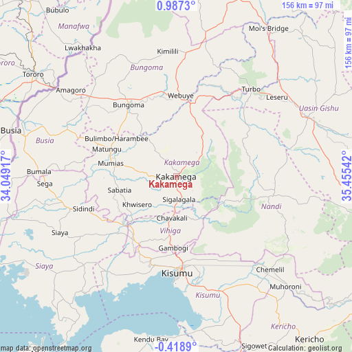
Kakamega GPS coordinates[2]
0° 17' 3.192" North, 34° 45' 8.244" East
| Map corner | latitude | longitude |
|---|---|---|
| Upper-left | 0.9873°, | 34.04917° |
| Center: | 0.28422°, | 34.75229° |
| Lower-right: | -0.4189°, | 35.45542° |
| Map W x H: | 156.4×156.4 km | = 97.2×97.2mi |
| max Lat: | 3.93726° ⇑21.9% North |
| Kakamega: | 0.28422° |
| min Lat: | ⇓78.1% South -4.64756° |
| min Long | Kakamega | max Long |
| 33.97248° | 34.75229° | 41.85688° |
| W 18.4%⇐ | ⇒81.6% E |
Elevation
Elevation of Kakamega is 1563 m = 5128 ft, and this is 216.3 m = 710 ft above average elevation for this country.
| Max E: |
2514 m = 8248 ft | 42.1% |
| Kakamega | 1563 m 5128 ft | |
| Avg. | 1346.7 m = 4418 ft | |
Min E: |
7 m = 23 ft | 57.9% |
See also: Kakamega elevation on elevation.city.
Geographical zone
Kakamega is located in North Torrid zone (between Equator and Tropic of Cancer). Distance of Equator is 31.6 km =19.6 mi to South.| Distance of | km | miles | from Kakamega |
|---|---|---|---|
| North Pole | 9975.5 | 6198.5 | to North |
| Arctic Circle | 7369.6 | 4579.3 | to North |
| Tropic Cancer | 2574.3 | 1599.6 | to North |
| Equator | 31.6 | 19.6 | to South |


Nearby cities:
15 places around Kakamega: (largest is in red/bold)
• Ahero
54.2 km =33.7 mi,  160°
160°
• Bondo
52.7 km =32.7 mi,  264°
264°
• Bungoma
37.7 km =23.4 mi,  325°
325°
• Bungoma
38.2 km =23.7 mi, 330°
• Butere
30.4 km =18.9 mi,  253°
253°
• Kapsabet
40.2 km =25 mi,  102°
102°
• Kisumu
43 km =26.7 mi,  178°
178°
• Lugulu
51.3 km =31.9 mi,  283°
283°
• Malikisi
57.1 km =35.5 mi,  319°
319°
• Mbale
22.7 km =14.1 mi,  188°
188°
• Mumias
29.9 km =18.6 mi, 280°
• Nandi Hills
52.1 km =32.4 mi,  112°
112°
• Siaya
57.3 km =35.6 mi,  244°
244°
• Webuye
35.2 km =21.9 mi,  3°
3°
• Yala
32 km =19.9 mi,  228°
228°
Sources, notices
• [Note1] Compared only with cities in Kenya existing in our database
• [Src1] Map data: © OpenStreetMap contributors (CC-BY-SA)
• [Src2] Other city data from geonames.org with taken over terms of usage.
• [Src3] Geographical zone / Annual Mean Temperature by Robert A. Rohde @ Wikipedia
