Butere geodata
Butere (Kakamega) is a populated place; located in Kenya in Africa/Nairobi (GMT+3) time zone. With population of 11,205 people, there are 61 cities with bigger population in this country. Compared to other cities in Kenya, 74.6% of cities are located further ↓South; 88.6% of cities are located further →East and 59.6% of cities have higher elevation than Butere. Note1


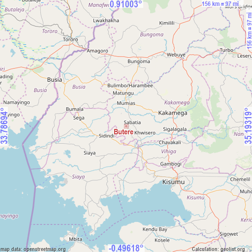
Butere GPS coordinates[2]
0° 12' 24.984" North, 34° 29' 24.216" East
| Map corner | latitude | longitude |
|---|---|---|
| Upper-left | 0.91003°, | 33.78694° |
| Center: | 0.20694°, | 34.49006° |
| Lower-right: | -0.49618°, | 35.19319° |
| Map W x H: | 156.4×156.4 km | = 97.2×97.2mi |
| max Lat: | 3.93726° ⇑25.4% North |
| Butere: | 0.20694° |
| min Lat: | ⇓74.6% South -4.64756° |
| min Long | Butere | max Long |
| 33.97248° | 34.49006° | 41.85688° |
| W 11.4%⇐ | ⇒88.6% E |
Elevation
Elevation of Butere is 1316 m = 4318 ft, and this is 30.7 m = 101 ft below average elevation for this country.
| Max E: |
2514 m = 8248 ft | 59.6% |
| Avg. | 1346.7 m = 4418 ft | |
| Butere | 1316 m = 4318 ft | |
Min E: |
7 m = 23 ft | 40.4% |
See also: Kenya elevation on elevation.city.
Geographical zone
Butere is located in North Torrid zone (between Equator and Tropic of Cancer). Distance of Equator is 23 km =14.3 mi to South.| Distance of | km | miles | from Butere |
|---|---|---|---|
| North Pole | 9984.1 | 6203.8 | to North |
| Arctic Circle | 7378.2 | 4584.6 | to North |
| Tropic Cancer | 2582.9 | 1604.9 | to North |
| Equator | 23 | 14.3 | to South |


Nearby cities:
15 places around Butere: (largest is in red/bold)
• Bondo
23.5 km =14.6 mi,  277°
277°
• Bungoma
40.4 km =25.1 mi,  11°
11°
• Bungoma
43.1 km =26.8 mi, 13°
• Busia
50.6 km =31.4 mi,  303°
303°
• Kakamega
30.4 km =18.9 mi,  73°
73°
• Kisumu
45.8 km =28.5 mi,  138°
138°
• Luanda
48 km =29.8 mi, 284°
• Lugulu
29.3 km =18.2 mi,  315°
315°
• Malaba
52.9 km =32.9 mi,  334°
334°
• Malikisi
52.8 km =32.8 mi,  351°
351°
• Mbale
29.2 km =18.1 mi,  118°
118°
• Mumias
14.2 km =8.8 mi,  359°
359°
• Nambare
38.4 km =23.9 mi, 316°
• Siaya
27.7 km =17.2 mi,  234°
234°
• Yala
13.5 km =8.4 mi,  157°
157°
Sources, notices
• [Note1] Compared only with cities in Kenya existing in our database
• [Src1] Map data: © OpenStreetMap contributors (CC-BY-SA)
• [Src2] Other city data from geonames.org with taken over terms of usage.
• [Src3] Geographical zone / Annual Mean Temperature by Robert A. Rohde @ Wikipedia
