Malaba geodata
Malaba (Busia) is a populated place; located in Kenya in Africa/Nairobi (GMT+3) time zone. With population of 8,383 people, there are 75 cities with bigger population in this country. Compared to other cities in Kenya, 89.5% of cities are located further ↓South; 94.7% of cities are located further →East and 69.3% of cities have higher elevation than Malaba. Note1


Malaba GPS coordinates[2]
0° 38' 6.468" North, 34° 16' 53.94" East
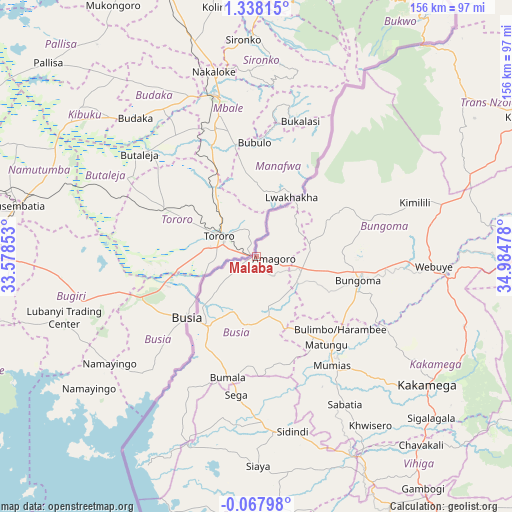
| Map corner | latitude | longitude |
|---|---|---|
| Upper-left | 1.33815°, | 33.57853° |
| Center: | 0.63513°, | 34.28165° |
| Lower-right: | -0.06798°, | 34.98478° |
| Map W x H: | 156.3×156.4 km | = 97.1×97.2mi |
| max Lat: | 3.93726° ⇑10.5% North |
| Malaba: | 0.63513° |
| min Lat: | ⇓89.5% South -4.64756° |
| min Long | Malaba | max Long |
| 33.97248° | 34.28165° | 41.85688° |
| W 5.3%⇐ | ⇒94.7% E |
Elevation
Elevation of Malaba is 1193 m = 3914 ft, and this is 153.7 m = 504 ft below average elevation for this country.
| Max E: |
2514 m = 8248 ft | 69.3% |
| Avg. | 1346.7 m = 4418 ft | |
| Malaba | 1193 m = 3914 ft | |
Min E: |
7 m = 23 ft | 30.7% |
See also: Kenya elevation on elevation.city.
Geographical zone
Malaba is located in North Torrid zone (between Equator and Tropic of Cancer). Distance of Equator is 70.6 km =43.9 mi to South.| Distance of | km | miles | from Malaba |
|---|---|---|---|
| North Pole | 9936.4 | 6174.2 | to North |
| Arctic Circle | 7330.6 | 4555 | to North |
| Tropic Cancer | 2535.3 | 1575.4 | to North |
| Equator | 70.6 | 43.9 | to South |


Nearby cities:
15 places around Malaba: (largest is in red/bold)
• Bondo
44.5 km =27.7 mi,  180°
180°
• Bungoma
32 km =19.9 mi,  104°
104°
• Bungoma
34 km =21.1 mi, 99°
• Busia
27.1 km =16.8 mi,  224°
224°
• Butere
52.9 km =32.9 mi,  154°
154°
• Kakamega
65.3 km =40.6 mi,  126°
126°
• Luanda
42.7 km =26.5 mi,  213°
213°
• Lugulu
27 km =16.8 mi,  174°
174°
• Malikisi
16.2 km =10.1 mi,  73°
73°
• Mumias
40.5 km =25.2 mi, 145°
• Nambare
19.9 km =12.4 mi,  189°
189°
• Siaya
63.9 km =39.7 mi, 179°
• Sirisia
65.6 km =40.8 mi, 208°
• Webuye
54.6 km =33.9 mi,  94°
94°
• Yala
66.4 km =41.3 mi, 154°
Sources, notices
• [Note1] Compared only with cities in Kenya existing in our database
• [Src1] Map data: © OpenStreetMap contributors (CC-BY-SA)
• [Src2] Other city data from geonames.org with taken over terms of usage.
• [Src3] Geographical zone / Annual Mean Temperature by Robert A. Rohde @ Wikipedia
