Mumias geodata
Mumias (Kakamega) is a populated place; located in Kenya in Africa/Nairobi (GMT+3) time zone. With population of 45,485 people, there are 18 cities with bigger population in this country. Compared to other cities in Kenya, 79.8% of cities are located further ↓South; 89.5% of cities are located further →East and 62.3% of cities have higher elevation than Mumias. Note1


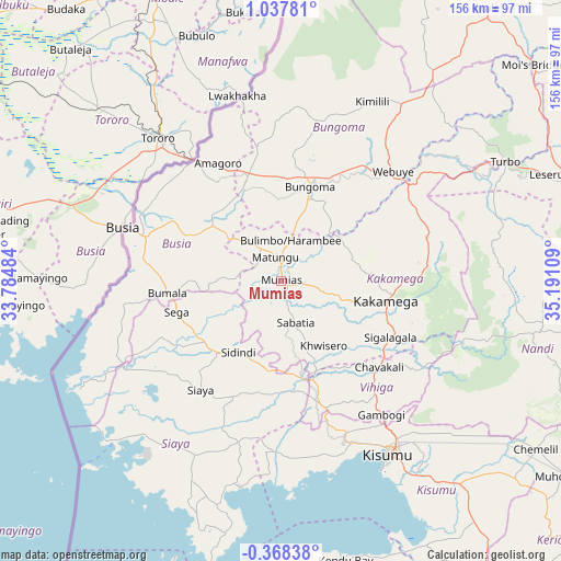
Mumias GPS coordinates[2]
0° 20' 5.064" North, 34° 29' 16.656" East
| Map corner | latitude | longitude |
|---|---|---|
| Upper-left | 1.03781°, | 33.78484° |
| Center: | 0.33474°, | 34.48796° |
| Lower-right: | -0.36838°, | 35.19109° |
| Map W x H: | 156.4×156.4 km | = 97.2×97.2mi |
| max Lat: | 3.93726° ⇑20.2% North |
| Mumias: | 0.33474° |
| min Lat: | ⇓79.8% South -4.64756° |
| min Long | Mumias | max Long |
| 33.97248° | 34.48796° | 41.85688° |
| W 10.5%⇐ | ⇒89.5% E |
Elevation
Elevation of Mumias is 1258 m = 4127 ft, and this is 88.7 m = 291 ft below average elevation for this country.
| Max E: |
2514 m = 8248 ft | 62.3% |
| Avg. | 1346.7 m = 4418 ft | |
| Mumias | 1258 m = 4127 ft | |
Min E: |
7 m = 23 ft | 37.7% |
See also: Mumias elevation on elevation.city.
Geographical zone
Mumias is located in North Torrid zone (between Equator and Tropic of Cancer). Distance of Equator is 37.2 km =23.1 mi to South.| Distance of | km | miles | from Mumias |
|---|---|---|---|
| North Pole | 9969.8 | 6194.9 | to North |
| Arctic Circle | 7364 | 4575.8 | to North |
| Tropic Cancer | 2568.7 | 1596.1 | to North |
| Equator | 37.2 | 23.1 | to South |


Nearby cities:
15 places around Mumias: (largest is in red/bold)
• Bondo
25.5 km =15.8 mi,  244°
244°
• Bungoma
26.7 km =16.6 mi,  17°
17°
• Bungoma
29.6 km =18.4 mi, 20°
• Busia
44.1 km =27.4 mi,  288°
288°
• Butere
14.2 km =8.8 mi,  179°
179°
• Kakamega
29.9 km =18.6 mi,  100°
100°
• Luanda
46.4 km =28.8 mi,  267°
267°
• Lugulu
21.5 km =13.4 mi, 287°
• Malaba
40.5 km =25.2 mi,  325°
325°
• Malikisi
38.8 km =24.1 mi,  349°
349°
• Mbale
38.2 km =23.7 mi,  137°
137°
• Nambare
29.5 km =18.3 mi,  297°
297°
• Siaya
37.7 km =23.4 mi,  216°
216°
• Webuye
43.2 km =26.8 mi,  46°
46°
• Yala
27.3 km =17 mi,  168°
168°
Sources, notices
• [Note1] Compared only with cities in Kenya existing in our database
• [Src1] Map data: © OpenStreetMap contributors (CC-BY-SA)
• [Src2] Other city data from geonames.org with taken over terms of usage.
• [Src3] Geographical zone / Annual Mean Temperature by Robert A. Rohde @ Wikipedia
