Bungoma geodata
Bungoma is a seat of a first-order administrative division; located in Kenya in Africa/Nairobi (GMT+3) time zone. With population of 55,962 people, there are 11 cities with bigger population in this country. Compared to other cities in Kenya, 86.8% of cities are located further ↓South; 86.8% of cities are located further →East and 52.6% of cities have higher elevation than Bungoma. Note1


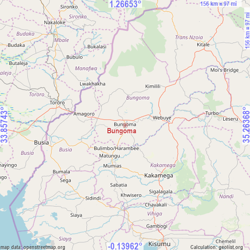
Bungoma GPS coordinates[2]
0° 33' 48.6" North, 34° 33' 37.98" East
| Map corner | latitude | longitude |
|---|---|---|
| Upper-left | 1.26653°, | 33.85743° |
| Center: | 0.5635°, | 34.56055° |
| Lower-right: | -0.13962°, | 35.26368° |
| Map W x H: | 156.3×156.4 km | = 97.1×97.2mi |
| max Lat: | 3.93726° ⇑13.2% North |
| Bungoma: | 0.5635° |
| min Lat: | ⇓86.8% South -4.64756° |
| min Long | Bungoma | max Long |
| 33.97248° | 34.56055° | 41.85688° |
| W 13.2%⇐ | ⇒86.8% E |
Elevation
Elevation of Bungoma is 1427 m = 4682 ft, and this is 80.3 m = 263 ft above average elevation for this country.
| Max E: |
2514 m = 8248 ft | 52.6% |
| Bungoma | 1427 m 4682 ft | |
| Avg. | 1346.7 m = 4418 ft | |
Min E: |
7 m = 23 ft | 47.4% |
See also: Bungoma elevation on elevation.city.
Geographical zone
Bungoma is located in North Torrid zone (between Equator and Tropic of Cancer). Distance of Equator is 62.7 km =39 mi to South.| Distance of | km | miles | from Bungoma |
|---|---|---|---|
| North Pole | 9944.4 | 6179.2 | to North |
| Arctic Circle | 7338.5 | 4559.9 | to North |
| Tropic Cancer | 2543.3 | 1580.3 | to North |
| Equator | 62.7 | 39 | to South |


Nearby cities:
15 places around Bungoma: (largest is in red/bold)
• Bondo
48 km =29.8 mi,  220°
220°
• Bungoma
3.4 km =2.1 mi,  48°
48°
• Busia
51.2 km =31.8 mi,  257°
257°
• Butere
40.4 km =25.1 mi,  191°
191°
• Kakamega
37.7 km =23.4 mi,  145°
145°
• Luanda
61.1 km =38 mi,  242°
242°
• Lugulu
34.2 km =21.3 mi, 236°
• Malaba
32 km =19.9 mi,  284°
284°
• Malikisi
19.9 km =12.4 mi,  309°
309°
• Mbale
56.4 km =35 mi,  161°
161°
• Mumias
26.7 km =16.6 mi,  197°
197°
• Nambare
36.1 km =22.4 mi,  251°
251°
• Siaya
63.6 km =39.5 mi,  208°
208°
• Webuye
23.8 km =14.8 mi,  80°
80°
• Yala
52.2 km =32.4 mi,  182°
182°
Sources, notices
• [Note1] Compared only with cities in Kenya existing in our database
• [Src1] Map data: © OpenStreetMap contributors (CC-BY-SA)
• [Src2] Other city data from geonames.org with taken over terms of usage.
• [Src3] Geographical zone / Annual Mean Temperature by Robert A. Rohde @ Wikipedia
