Bungoma geodata
Bungoma is a seat of a second-order administrative division; located in Kenya in Africa/Nairobi (GMT+3) time zone. In our database, there are 111 cities with bigger population. Compared to other cities in Kenya, 87.7% of cities are located further ↓South; 86% of cities are located further →East and 50.9% of cities have higher elevation than Bungoma. Note1


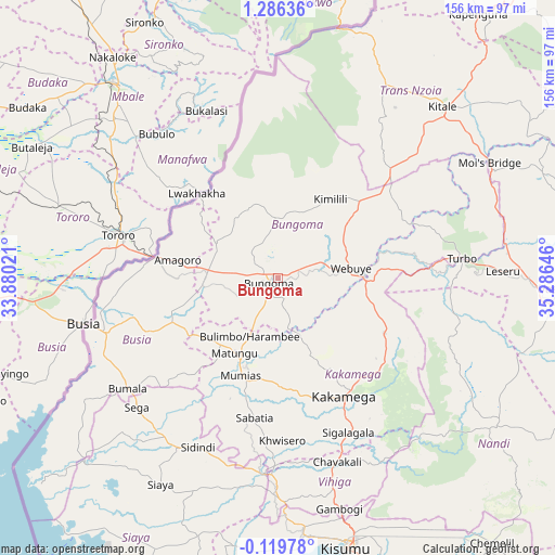
Bungoma GPS coordinates[2]
0° 34' 59.988" North, 34° 34' 59.988" East
| Map corner | latitude | longitude |
|---|---|---|
| Upper-left | 1.28636°, | 33.88021° |
| Center: | 0.58333°, | 34.58333° |
| Lower-right: | -0.11978°, | 35.28646° |
| Map W x H: | 156.3×156.4 km | = 97.1×97.2mi |
| max Lat: | 3.93726° ⇑12.3% North |
| Bungoma: | 0.58333° |
| min Lat: | ⇓87.7% South -4.64756° |
| min Long | Bungoma | max Long |
| 33.97248° | 34.58333° | 41.85688° |
| W 14%⇐ | ⇒86% E |
Elevation
Elevation of Bungoma is 1452 m = 4764 ft, and this is 105.3 m = 345 ft above average elevation for this country.
| Max E: |
2514 m = 8248 ft | 50.9% |
| Bungoma | 1452 m 4764 ft | |
| Avg. | 1346.7 m = 4418 ft | |
Min E: |
7 m = 23 ft | 49.1% |
See also: Kenya elevation on elevation.city.
Geographical zone
Bungoma is located in North Torrid zone (between Equator and Tropic of Cancer). Distance of Equator is 64.9 km =40.3 mi to South.| Distance of | km | miles | from Bungoma |
|---|---|---|---|
| North Pole | 9942.2 | 6177.8 | to North |
| Arctic Circle | 7336.3 | 4558.6 | to North |
| Tropic Cancer | 2541.1 | 1579 | to North |
| Equator | 64.9 | 40.3 | to South |


Nearby cities:
15 places around Bungoma: (largest is in red/bold)
• Bondo
51.3 km =31.9 mi,  220°
220°
• Bungoma
3.4 km =2.1 mi,  228°
228°
• Busia
54.2 km =33.7 mi,  255°
255°
• Butere
43.1 km =26.8 mi,  193°
193°
• Kakamega
38.2 km =23.7 mi,  150°
150°
• Luanda
64.3 km =40 mi,  242°
242°
• Lugulu
37.6 km =23.4 mi, 235°
• Malaba
34 km =21.1 mi,  279°
279°
• Malikisi
20.8 km =12.9 mi,  300°
300°
• Mbale
57.8 km =35.9 mi,  164°
164°
• Mumias
29.6 km =18.4 mi,  200°
200°
• Nambare
39.2 km =24.4 mi,  249°
249°
• Siaya
66.7 km =41.4 mi,  209°
209°
• Webuye
21 km =13 mi,  84°
84°
• Yala
54.6 km =33.9 mi, 185°
Sources, notices
• [Note1] Compared only with cities in Kenya existing in our database
• [Src1] Map data: © OpenStreetMap contributors (CC-BY-SA)
• [Src2] Other city data from geonames.org with taken over terms of usage.
• [Src3] Geographical zone / Annual Mean Temperature by Robert A. Rohde @ Wikipedia
