Siaya geodata
Siaya is a seat of a first-order administrative division; located in Kenya in Africa/Nairobi (GMT+3) time zone. With population of 15,354 people, there are 49 cities with bigger population in this country. Compared to other cities in Kenya, 68.4% of cities are located further ↓South; 93.9% of cities are located further →East and 57.9% of cities have higher elevation than Siaya. Note1


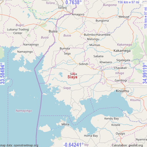
Siaya GPS coordinates[2]
0° 3' 38.52" North, 34° 17' 17.016" East
| Map corner | latitude | longitude |
|---|---|---|
| Upper-left | 0.7638°, | 33.58494° |
| Center: | 0.0607°, | 34.28806° |
| Lower-right: | -0.64241°, | 34.99119° |
| Map W x H: | 156.4×156.4 km | = 97.2×97.2mi |
| max Lat: | 3.93726° ⇑31.6% North |
| Siaya: | 0.0607° |
| min Lat: | ⇓68.4% South -4.64756° |
| min Long | Siaya | max Long |
| 33.97248° | 34.28806° | 41.85688° |
| W 6.1%⇐ | ⇒93.9% E |
Elevation
Elevation of Siaya is 1321 m = 4334 ft, and this is 25.7 m = 84 ft below average elevation for this country.
| Max E: |
2514 m = 8248 ft | 57.9% |
| Avg. | 1346.7 m = 4418 ft | |
| Siaya | 1321 m = 4334 ft | |
Min E: |
7 m = 23 ft | 42.1% |
See also: Kenya elevation on elevation.city.
Geographical zone
Siaya is located in North Torrid zone (between Equator and Tropic of Cancer). Distance of Equator is 6.7 km =4.2 mi to South.| Distance of | km | miles | from Siaya |
|---|---|---|---|
| North Pole | 10000.3 | 6213.9 | to North |
| Arctic Circle | 7394.4 | 4594.7 | to North |
| Tropic Cancer | 2599.2 | 1615.1 | to North |
| Equator | 6.7 | 4.2 | to South |


Nearby cities:
15 places around Siaya: (largest is in red/bold)
• Bondo
19.4 km =12.1 mi,  357°
357°
• Bungoma
63.6 km =39.5 mi,  28°
28°
• Busia
48.5 km =30.1 mi,  336°
336°
• Butere
27.7 km =17.2 mi,  54°
54°
• Kakamega
57.3 km =35.6 mi,  64°
64°
• Kisumu
55.7 km =34.6 mi,  108°
108°
• Luanda
37 km =23 mi,  319°
319°
• Lugulu
37 km =23 mi,  2°
2°
• Malaba
63.9 km =39.7 mi, 359°
• Mbale
48.2 km =30 mi,  87°
87°
• Mumias
37.7 km =23.4 mi,  36°
36°
• Nambare
44.4 km =27.6 mi, 355°
• Port Victoria
35.3 km =21.9 mi,  276°
276°
• Sirisia
32.6 km =20.3 mi, 280°
• Yala
27.8 km =17.3 mi,  82°
82°
Sources, notices
• [Note1] Compared only with cities in Kenya existing in our database
• [Src1] Map data: © OpenStreetMap contributors (CC-BY-SA)
• [Src2] Other city data from geonames.org with taken over terms of usage.
• [Src3] Geographical zone / Annual Mean Temperature by Robert A. Rohde @ Wikipedia
