Uzgen geodata
Uzgen (Osh) is a populated place; located in Kyrgyzstan in Asia/Bishkek (GMT+6) time zone. With population of 40,360 people, there are 7 cities with bigger population in this country. Compared to other cities in Kyrgyzstan, 52.4% of cities are located further ↑North; 65.5% of cities are located further ←West and 54.8% of cities have higher elevation than Uzgen. Note1


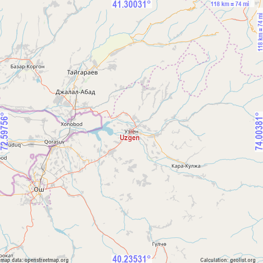
Uzgen GPS coordinates[2]
40° 46' 11.784" North, 73° 18' 2.448" East
| Map corner | latitude | longitude |
|---|---|---|
| Upper-left | 41.30031°, | 72.59756° |
| Center: | 40.76994°, | 73.30068° |
| Lower-right: | 40.23531°, | 74.00381° |
| Map W x H: | 118.4×118.4 km | = 73.6×73.6mi |
| max Lat: | 42.89106° ⇑52.4% North |
| Uzgen: | 40.76994° |
| min Lat: | ⇓47.6% South 39.55274° |
| min Long | Uzgen | max Long |
| 69.3716° | 73.30068° | 78.52702° |
| W 65.5%⇐ | ⇒34.5% E |
Elevation
Elevation of Uzgen is 1027 m = 3369 ft, and this is 174.4 m = 572 ft below average elevation for this country.
| Max E: |
2638 m = 8655 ft | 54.8% |
| Avg. | 1201.4 m = 3942 ft | |
| Uzgen | 1027 m = 3369 ft | |
Min E: |
504 m = 1654 ft | 45.2% |
See also: Uzgen elevation on elevation.city.
Geographical zone
Uzgen is located in North temperate zone (between Tropic of Cancer and the Arctic Circle). Distance of this Northern Tropic circle is 1927.3 km =1197.6 mi to South.| Distance of | km | miles | from Uzgen |
|---|---|---|---|
| North Pole | 5473.9 | 3401.3 | to North |
| Arctic Circle | 2868 | 1782.1 | to North |
| Tropic Cancer | 1927.3 | 1197.6 | to South |
| Equator | 4533.2 | 2816.8 | to South |


Nearby cities:
15 places around Uzgen: (largest is in red/bold)
• Aravan
73.2 km =45.5 mi,  247°
247°
• Bazar-Korgon
55.3 km =34.4 mi,  302°
302°
• Gul’cha
52.1 km =32.4 mi,  166°
166°
• Jalal-Abad
31.1 km =19.3 mi,  305°
305°
• Kara Suu
37.3 km =23.2 mi,  258°
258°
• Kara-Kulja
29 km =18 mi,  121°
121°
• Karavan
108 km =67.1 mi,  240°
240°
• Kazarman
93.3 km =58 mi,  40°
40°
• Kochkor-Ata
74.8 km =46.5 mi,  293°
293°
• Massy
64.7 km =40.2 mi, 299°
• Nookat
80.4 km =50 mi,  225°
225°
• Osh
50.2 km =31.2 mi, 237°
• Suzak
36.2 km =22.5 mi, 293°
• Tash-Kumyr
111.2 km =69.1 mi, 305°
• Üch-Terek
110.6 km =68.7 mi,  355°
355°
Sources, notices
• [Note1] Compared only with cities in Kyrgyzstan existing in our database
• [Src1] Map data: © OpenStreetMap contributors (CC-BY-SA)
• [Src2] Other city data from geonames.org with taken over terms of usage.
• [Src3] Geographical zone / Annual Mean Temperature by Robert A. Rohde @ Wikipedia
