Suzak geodata
Suzak (Jalal-Abad) is a seat of a second-order administrative division; located in Kyrgyzstan in Asia/Bishkek (GMT+6) time zone. In our database, there are 37 cities with bigger population. Compared to other cities in Kyrgyzstan, 51.2% of cities are located further ↑North; 60.7% of cities are located further ←West and 94% of cities have higher elevation than Suzak. Note1


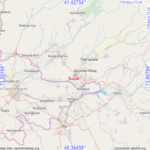
Suzak GPS coordinates[2]
40° 53' 53.52" North, 72° 54' 17.316" East
| Map corner | latitude | longitude |
|---|---|---|
| Upper-left | 41.42754°, | 72.20169° |
| Center: | 40.8982°, | 72.90481° |
| Lower-right: | 40.36459°, | 73.60794° |
| Map W x H: | 118.2×118.2 km | = 73.4×73.4mi |
| max Lat: | 42.89106° ⇑51.2% North |
| Suzak: | 40.8982° |
| min Lat: | ⇓48.8% South 39.55274° |
| min Long | Suzak | max Long |
| 69.3716° | 72.90481° | 78.52702° |
| W 60.7%⇐ | ⇒39.3% E |
Elevation
Elevation of Suzak is 714 m = 2343 ft, and this is 487.4 m = 1599 ft below average elevation for this country.
| Max E: |
2638 m = 8655 ft | 94% |
| Avg. | 1201.4 m = 3942 ft | |
| Suzak | 714 m = 2343 ft | |
Min E: |
504 m = 1654 ft | 6% |
See also: Kyrgyzstan elevation on elevation.city.
Geographical zone
Suzak is located in North temperate zone (between Tropic of Cancer and the Arctic Circle). Distance of this Northern Tropic circle is 1941.5 km =1206.4 mi to South.| Distance of | km | miles | from Suzak |
|---|---|---|---|
| North Pole | 5459.6 | 3392.4 | to North |
| Arctic Circle | 2853.7 | 1773.2 | to North |
| Tropic Cancer | 1941.5 | 1206.4 | to South |
| Equator | 4547.5 | 2825.7 | to South |


Nearby cities:
15 places around Suzak: (largest is in red/bold)
• Aravan
54.5 km =33.9 mi,  218°
218°
• Bazar-Korgon
20.5 km =12.7 mi,  319°
319°
• Gul’cha
79.3 km =49.3 mi,  144°
144°
• Iradan
97.7 km =60.7 mi, 224°
• Jalal-Abad
8.9 km =5.5 mi,  63°
63°
• Kara Suu
21.8 km =13.5 mi,  188°
188°
• Kara-Kulja
65 km =40.4 mi,  117°
117°
• Karavan
90.4 km =56.2 mi, 222°
• Kochkor-Ata
38.6 km =24 mi,  293°
293°
• Kyzyl-Kyya
96.9 km =60.2 mi, 222°
• Massy
29.1 km =18.1 mi,  308°
308°
• Nookat
74.3 km =46.2 mi,  198°
198°
• Osh
42.1 km =26.2 mi, 192°
• Tash-Kumyr
76.1 km =47.3 mi, 310°
• Uzgen
36.2 km =22.5 mi,  113°
113°
Sources, notices
• [Note1] Compared only with cities in Kyrgyzstan existing in our database
• [Src1] Map data: © OpenStreetMap contributors (CC-BY-SA)
• [Src2] Other city data from geonames.org with taken over terms of usage.
• [Src3] Geographical zone / Annual Mean Temperature by Robert A. Rohde @ Wikipedia
