Gul’cha geodata
Gul’cha (Osh) is a seat of a second-order administrative division; located in Kyrgyzstan in Asia/Bishkek (GMT+6) time zone. In our database, there are 37 cities with bigger population. Compared to other cities in Kyrgyzstan, 58.3% of cities are located further ↑North; 66.7% of cities are located further ←West and 75% of cities have lower elevation than Gul’cha. Note1


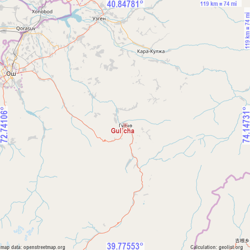
Gul’cha GPS coordinates[2]
40° 18' 49.68" North, 73° 26' 39.048" East
| Map corner | latitude | longitude |
|---|---|---|
| Upper-left | 40.84781°, | 72.74106° |
| Center: | 40.3138°, | 73.44418° |
| Lower-right: | 39.77553°, | 74.14731° |
| Map W x H: | 119.2×119.2 km | = 74.1×74.1mi |
| max Lat: | 42.89106° ⇑58.3% North |
| Gul’cha: | 40.3138° |
| min Lat: | ⇓41.7% South 39.55274° |
| min Long | Gul’cha | max Long |
| 69.3716° | 73.44418° | 78.52702° |
| W 66.7%⇐ | ⇒33.3% E |
Elevation
Elevation of Gul’cha is 1546 m = 5072 ft, and this is 344.6 m = 1131 ft above average elevation for this country.
| Max E: |
2638 m = 8655 ft | 25% |
| Gul’cha | 1546 m 5072 ft | |
| Avg. | 1201.4 m = 3942 ft | |
Min E: |
504 m = 1654 ft | 75% |
See also: Kyrgyzstan elevation on elevation.city.
Geographical zone
Gul’cha is located in North temperate zone (between Tropic of Cancer and the Arctic Circle). Distance of this Northern Tropic circle is 1876.6 km =1166.1 mi to South.| Distance of | km | miles | from Gul’cha |
|---|---|---|---|
| North Pole | 5524.6 | 3432.8 | to North |
| Arctic Circle | 2918.7 | 1813.6 | to North |
| Tropic Cancer | 1876.6 | 1166.1 | to South |
| Equator | 4482.5 | 2785.3 | to South |


Nearby cities:
15 places around Gul’cha: (largest is in red/bold)
• Aravan
83.1 km =51.6 mi,  285°
285°
• Bazar-Korgon
99.7 km =62 mi,  323°
323°
• Iradan
114.1 km =70.9 mi,  267°
267°
• Jalal-Abad
78.4 km =48.7 mi,  331°
331°
• Kara Suu
65.4 km =40.6 mi,  311°
311°
• Kara-Dzhygach
116.7 km =72.5 mi,  259°
259°
• Kara-Kulja
37.6 km =23.4 mi,  19°
19°
• Karavan
106.7 km =66.3 mi, 268°
• Kochkor-Ata
114.2 km =71 mi, 314°
• Kyzyl-Kyya
111.8 km =69.5 mi, 266°
• Massy
107.5 km =66.8 mi, 320°
• Nookat
70.2 km =43.6 mi, 265°
• Osh
59.6 km =37 mi, 293°
• Suzak
79.3 km =49.3 mi, 324°
• Uzgen
52.1 km =32.4 mi,  346°
346°
Sources, notices
• [Note1] Compared only with cities in Kyrgyzstan existing in our database
• [Src1] Map data: © OpenStreetMap contributors (CC-BY-SA)
• [Src2] Other city data from geonames.org with taken over terms of usage.
• [Src3] Geographical zone / Annual Mean Temperature by Robert A. Rohde @ Wikipedia
