Kara Suu geodata
Kara Suu (Osh) is a seat of a second-order administrative division; located in Kyrgyzstan in Asia/Bishkek (GMT+6) time zone. With population of 17,800 people, there are 17 cities with bigger population in this country. Compared to other cities in Kyrgyzstan, 53.6% of cities are located further ↑North; 59.5% of cities are located further ←West and 84.5% of cities have higher elevation than Kara Suu. Note1


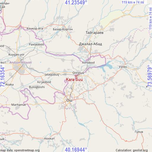
Kara Suu GPS coordinates[2]
40° 42' 16.56" North, 72° 51' 59.976" East
| Map corner | latitude | longitude |
|---|---|---|
| Upper-left | 41.23549°, | 72.16354° |
| Center: | 40.7046°, | 72.86666° |
| Lower-right: | 40.16944°, | 73.56979° |
| Map W x H: | 118.5×118.5 km | = 73.6×73.6mi |
| max Lat: | 42.89106° ⇑53.6% North |
| Kara Suu: | 40.7046° |
| min Lat: | ⇓46.4% South 39.55274° |
| min Long | Kara Suu | max Long |
| 69.3716° | 72.86666° | 78.52702° |
| W 59.5%⇐ | ⇒40.5% E |
Elevation
Elevation of Kara Suu is 744 m = 2441 ft, and this is 457.4 m = 1501 ft below average elevation for this country.
| Max E: |
2638 m = 8655 ft | 84.5% |
| Avg. | 1201.4 m = 3942 ft | |
| Kara Suu | 744 m = 2441 ft | |
Min E: |
504 m = 1654 ft | 15.5% |
See also: Kyrgyzstan elevation on elevation.city.
Geographical zone
Kara Suu is located in North temperate zone (between Tropic of Cancer and the Arctic Circle). Distance of this Northern Tropic circle is 1920 km =1193 mi to South.| Distance of | km | miles | from Kara Suu |
|---|---|---|---|
| North Pole | 5481.1 | 3405.8 | to North |
| Arctic Circle | 2875.2 | 1786.6 | to North |
| Tropic Cancer | 1920 | 1193 | to South |
| Equator | 4525.9 | 2812.3 | to South |


Nearby cities:
15 places around Kara Suu: (largest is in red/bold)
• Aravan
37.4 km =23.2 mi,  235°
235°
• Bazar-Korgon
38.4 km =23.9 mi,  344°
344°
• Gul’cha
65.4 km =40.6 mi,  131°
131°
• Iradan
81.1 km =50.4 mi,  233°
233°
• Jalal-Abad
27.8 km =17.3 mi,  23°
23°
• Kara-Dëbë
86.3 km =53.6 mi, 233°
• Kara-Kulja
61.7 km =38.3 mi,  97°
97°
• Karavan
73.4 km =45.6 mi, 231°
• Kochkor-Ata
49.1 km =30.5 mi,  318°
318°
• Kyzyl-Kyya
79.9 km =49.6 mi, 231°
• Massy
44.1 km =27.4 mi,  333°
333°
• Nookat
53.1 km =33 mi,  203°
203°
• Osh
20.4 km =12.7 mi, 196°
• Suzak
21.8 km =13.5 mi,  8°
8°
• Uzgen
37.3 km =23.2 mi,  78°
78°
Sources, notices
• [Note1] Compared only with cities in Kyrgyzstan existing in our database
• [Src1] Map data: © OpenStreetMap contributors (CC-BY-SA)
• [Src2] Other city data from geonames.org with taken over terms of usage.
• [Src3] Geographical zone / Annual Mean Temperature by Robert A. Rohde @ Wikipedia
