Iwŏn-ŭp geodata
Iwŏn-ŭp (Hamgyŏng-namdo) is a populated place; located in North Korea in Asia/Pyongyang (GMT+9) time zone. With population of 26,364 people, there are 38 cities with bigger population in this country. Compared to other cities in North Korea, 56% of cities are located further ↓South; 65.9% of cities are located further ←West and 98.9% of cities have higher elevation than Iwŏn-ŭp. Note1


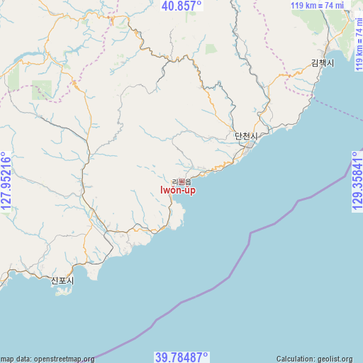
Iwŏn-ŭp GPS coordinates[2]
40° 19' 23.016" North, 128° 39' 19.008" East
| Map corner | latitude | longitude |
|---|---|---|
| Upper-left | 40.857°, | 127.95216° |
| Center: | 40.32306°, | 128.65528° |
| Lower-right: | 39.78487°, | 129.35841° |
| Map W x H: | 119.2×119.2 km | = 74.1×74.1mi |
| max Lat: | 42.95722° ⇑44% North |
| Iwŏn-ŭp: | 40.32306° |
| min Lat: | ⇓56% South 37.90889° |
| min Long | Iwŏn-ŭp | max Long |
| 124.39806° | 128.65528° | 130.49522° |
| W 65.9%⇐ | ⇒34.1% E |
Elevation
Elevation of Iwŏn-ŭp is 2 m = 7 ft, and this is 129.7 m = 426 ft below average elevation for this country.
| Max E: |
1466 m = 4810 ft | 98.9% |
| Avg. | 131.7 m = 432 ft | |
| Iwŏn-ŭp | 2 m = 7 ft | |
Min E: |
1 m = 3 ft | 1.1% |
See also: North Korea elevation on elevation.city.
Geographical zone
Iwŏn-ŭp is located in North temperate zone (between Tropic of Cancer and the Arctic Circle). Distance of this Northern Tropic circle is 1877.6 km =1166.7 mi to South.| Distance of | km | miles | from Iwŏn-ŭp |
|---|---|---|---|
| North Pole | 5523.6 | 3432.2 | to North |
| Arctic Circle | 2917.7 | 1813 | to North |
| Tropic Cancer | 1877.6 | 1166.7 | to South |
| Equator | 4483.5 | 2785.9 | to South |


Nearby cities:
15 places around Iwŏn-ŭp: (largest is in red/bold)
• Hamhŭng
105.2 km =65.4 mi,  244°
244°
• Hau-ri
119.3 km =74.1 mi,  35°
35°
• Hoemul-li
150.1 km =93.3 mi,  34°
34°
• Hongwŏn
68 km =42.3 mi, 240°
• Hyesan
126.5 km =78.6 mi,  341°
341°
• Hyesan-dong
126 km =78.3 mi, 341°
• Hŭngnam
103.8 km =64.5 mi, 238°
• Kapsan-ŭp
90.6 km =56.3 mi, 340°
• Kilju
91.1 km =56.6 mi, 38°
• Kimch’aek-si
59.3 km =36.8 mi,  49°
49°
• Samho-rodongjagu
78.7 km =48.9 mi, 237°
• Sinsang-ni
130.1 km =80.8 mi,  234°
234°
• Sŭngjibaegam
103 km =64 mi,  6°
6°
• Yuktae-dong
53.6 km =33.3 mi, 231°
• Yŏnggwang-ŭp
107.5 km =66.8 mi,  251°
251°
Sources, notices
• [Note1] Compared only with cities in North Korea existing in our database
• [Src1] Map data: © OpenStreetMap contributors (CC-BY-SA)
• [Src2] Other city data from geonames.org with taken over terms of usage.
• [Src3] Geographical zone / Annual Mean Temperature by Robert A. Rohde @ Wikipedia
