Pyeongchang geodata
Pyeongchang (Gangwon-do) is a populated place; located in South Korea in Asia/Seoul (GMT+9) time zone. With population of 9,940 people, there are 126 cities with bigger population in this country. Compared to other cities in South Korea, 77.3% of cities are located further ↓South; 82.9% of cities are located further ←West and 97.9% of cities have lower elevation than Pyeongchang. Note1


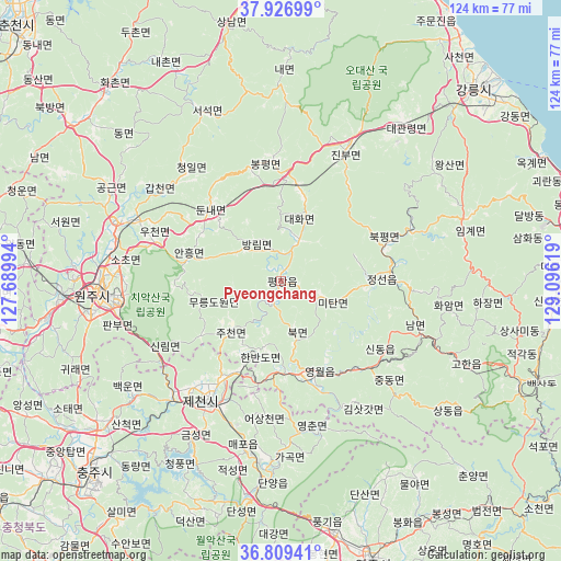
Pyeongchang GPS coordinates[2]
37° 22' 13.008" North, 128° 23' 35.016" East
| Map corner | latitude | longitude |
|---|---|---|
| Upper-left | 37.92699°, | 127.68994° |
| Center: | 37.37028°, | 128.39306° |
| Lower-right: | 36.80941°, | 129.09619° |
| Map W x H: | 124.3×124.3 km | = 77.2×77.2mi |
| max Lat: | 38.37881° ⇑22.7% North |
| Pyeongchang: | 37.37028° |
| min Lat: | ⇓77.3% South 33.25333° |
| min Long | Pyeongchang | max Long |
| 126.10863° | 128.39306° | 129.55377° |
| W 82.9%⇐ | ⇒17.1% E |
Elevation
Elevation of Pyeongchang is 300 m = 984 ft, and this is 229.6 m = 753 ft above average elevation for this country.
| Max E: |
691 m = 2267 ft | 2.1% |
| Pyeongchang | 300 m 984 ft | |
| Avg. | 70.4 m = 231 ft | |
Min E: |
1 m = 3 ft | 97.9% |
See also: South Korea elevation on elevation.city.
Geographical zone
Pyeongchang is located in North temperate zone (between Tropic of Cancer and the Arctic Circle). Distance of this Northern Tropic circle is 1549.3 km =962.7 mi to South.| Distance of | km | miles | from Pyeongchang |
|---|---|---|---|
| North Pole | 5851.9 | 3636.2 | to North |
| Arctic Circle | 3246 | 2017 | to North |
| Tropic Cancer | 1549.3 | 962.7 | to South |
| Equator | 4155.2 | 2581.9 | to South |


Nearby cities:
15 places around Pyeongchang: (largest is in red/bold)
• Dongnae
76.9 km =47.8 mi,  313°
313°
• Eisen
64.5 km =40.1 mi,  160°
160°
• Gangdong
63.5 km =39.5 mi,  51°
51°
• Gangneung
59.9 km =37.2 mi,  44°
44°
• Gujeong
57.8 km =35.9 mi, 47°
• Hongch’ŏn
57.3 km =35.6 mi, 308°
• Mungyeong
75 km =46.6 mi,  199°
199°
• Neietsu
21.7 km =13.5 mi, 162°
• Santyoku
69.1 km =42.9 mi,  83°
83°
• Seoseok
42.1 km =26.2 mi,  334°
334°
• Sindong
77.6 km =48.2 mi, 309°
• Tonghae
65.9 km =40.9 mi,  72°
72°
• T’aebaek
57 km =35.4 mi,  112°
112°
• Wŏnju
39.6 km =24.6 mi,  266°
266°
• Yeoju
67.6 km =42 mi,  262°
262°
Sources, notices
• [Note1] Compared only with cities in South Korea existing in our database
• [Src1] Map data: © OpenStreetMap contributors (CC-BY-SA)
• [Src2] Other city data from geonames.org with taken over terms of usage.
• [Src3] Geographical zone / Annual Mean Temperature by Robert A. Rohde @ Wikipedia
