Daegu geodata
Daegu is a seat of a first-order administrative division; located in South Korea in Asia/Seoul (GMT+9) time zone. With population of 2,566,540 people, there are 3 cities with bigger population in this country. Compared to other cities in South Korea, 51.7% of cities are located further ↑North; 87.4% of cities are located further ←West and 52.1% of cities have lower elevation than Daegu. Note1


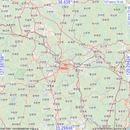
Daegu GPS coordinates[2]
35° 52' 13.008" North, 128° 35' 27.996" East
| Map corner | latitude | longitude |
|---|---|---|
| Upper-left | 36.438°, | 127.88799° |
| Center: | 35.87028°, | 128.59111° |
| Lower-right: | 35.29846°, | 129.29424° |
| Map W x H: | 126.7×126.7 km | = 78.7×78.7mi |
| max Lat: | 38.37881° ⇑51.7% North |
| Daegu: | 35.87028° |
| min Lat: | ⇓48.3% South 33.25333° |
| min Long | Daegu | max Long |
| 126.10863° | 128.59111° | 129.55377° |
| W 87.4%⇐ | ⇒12.6% E |
Elevation
Elevation of Daegu is 45 m = 148 ft, and this is 25.4 m = 83 ft below average elevation for this country.
| Max E: |
691 m = 2267 ft | 47.9% |
| Avg. | 70.4 m = 231 ft | |
| Daegu | 45 m = 148 ft | |
Min E: |
1 m = 3 ft | 52.1% |
See also: Daegu elevation on elevation.city.
Geographical zone
Daegu is located in North temperate zone (between Tropic of Cancer and the Arctic Circle). Distance of this Northern Tropic circle is 1382.5 km =859 mi to South.| Distance of | km | miles | from Daegu |
|---|---|---|---|
| North Pole | 6018.7 | 3739.8 | to North |
| Arctic Circle | 3412.8 | 2120.6 | to North |
| Tropic Cancer | 1382.5 | 859 | to South |
| Equator | 3988.4 | 2478.3 | to South |


Nearby cities:
15 places around Daegu: (largest is in red/bold)
• Changnyeong
37.6 km =23.4 mi,  193°
193°
• Chupungnyeong
66.3 km =41.2 mi,  305°
305°
• Daehap
30.5 km =19 mi,  200°
200°
• Eisen
32.4 km =20.1 mi,  70°
70°
• Gimcheon
50.8 km =31.6 mi,  303°
303°
• Gumi
35.5 km =22.1 mi,  319°
319°
• Gyeongju
56 km =34.8 mi,  93°
93°
• Gyeongsan-si
14.2 km =8.8 mi,  111°
111°
• Hayang
21.2 km =13.2 mi,  76°
76°
• Hwawŏn
11.2 km =7 mi,  226°
226°
• Hyeonpung
23.4 km =14.5 mi,  213°
213°
• Jenzan
48.9 km =30.4 mi,  327°
327°
• Kunwi
40.6 km =25.2 mi,  357°
357°
• Miryang
44.3 km =27.5 mi,  161°
161°
• Waegwan
22.1 km =13.7 mi, 307°
Sources, notices
• [Note1] Compared only with cities in South Korea existing in our database
• [Src1] Map data: © OpenStreetMap contributors (CC-BY-SA)
• [Src2] Other city data from geonames.org with taken over terms of usage.
• [Src3] Geographical zone / Annual Mean Temperature by Robert A. Rohde @ Wikipedia
