Santyoku geodata
Santyoku (Gangwon-do) is a populated place; located in South Korea in Asia/Seoul (GMT+9) time zone. With population of 42,145 people, there are 92 cities with bigger population in this country. Compared to other cities in South Korea, 78.7% of cities are located further ↓South; 95.1% of cities are located further ←West and 67.5% of cities have higher elevation than Santyoku. Note1


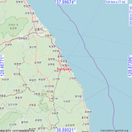
Santyoku GPS coordinates[2]
37° 26' 26.016" North, 129° 10' 14.988" East
| Map corner | latitude | longitude |
|---|---|---|
| Upper-left | 37.99674°, | 128.46771° |
| Center: | 37.44056°, | 129.17083° |
| Lower-right: | 36.88021°, | 129.87396° |
| Map W x H: | 124.1×124.1 km | = 77.1×77.1mi |
| max Lat: | 38.37881° ⇑21.3% North |
| Santyoku: | 37.44056° |
| min Lat: | ⇓78.7% South 33.25333° |
| min Long | Santyoku | max Long |
| 126.10863° | 129.17083° | 129.55377° |
| W 95.1%⇐ | ⇒4.9% E |
Elevation
Elevation of Santyoku is 23 m = 75 ft, and this is 47.4 m = 156 ft below average elevation for this country.
| Max E: |
691 m = 2267 ft | 67.5% |
| Avg. | 70.4 m = 231 ft | |
| Santyoku | 23 m = 75 ft | |
Min E: |
1 m = 3 ft | 32.5% |
See also: Santyoku elevation on elevation.city.
Geographical zone
Santyoku is located in North temperate zone (between Tropic of Cancer and the Arctic Circle). Distance of this Northern Tropic circle is 1557.1 km =967.5 mi to South.| Distance of | km | miles | from Santyoku |
|---|---|---|---|
| North Pole | 5844.1 | 3631.4 | to North |
| Arctic Circle | 3238.2 | 2012.1 | to North |
| Tropic Cancer | 1557.1 | 967.5 | to South |
| Equator | 4163 | 2586.8 | to South |


Nearby cities:
15 places around Santyoku: (largest is in red/bold)
• Andong
105 km =65.2 mi,  202°
202°
• Cheongsong gun
112.4 km =69.8 mi,  185°
185°
• Eisen
83.8 km =52.1 mi,  214°
214°
• Gangdong
37.3 km =23.2 mi,  329°
329°
• Gangneung
43.5 km =27 mi,  322°
322°
• Gujeong
40.2 km =25 mi, 320°
• Neietsu
68.3 km =42.4 mi,  245°
245°
• Pyeongchang
69.1 km =42.9 mi,  263°
263°
• Seoseok
91.8 km =57 mi,  289°
289°
• Sokcho
99.2 km =61.6 mi, 329°
• Tonghae
12.8 km =8 mi, 333°
• Toseong
105.4 km =65.5 mi, 329°
• T’aebaek
33.5 km =20.8 mi, 208°
• Wŏnju
108.7 km =67.5 mi, 264°
• Yecheon
107.8 km =67 mi,  216°
216°
Sources, notices
• [Note1] Compared only with cities in South Korea existing in our database
• [Src1] Map data: © OpenStreetMap contributors (CC-BY-SA)
• [Src2] Other city data from geonames.org with taken over terms of usage.
• [Src3] Geographical zone / Annual Mean Temperature by Robert A. Rohde @ Wikipedia
