T’aebaek geodata
T’aebaek (Gangwon-do) is a populated place; located in South Korea in Asia/Seoul (GMT+9) time zone. With population of 48,962 people, there are 85 cities with bigger population in this country. Compared to other cities in South Korea, 74.1% of cities are located further ↓South; 92.7% of cities are located further ←West and 100% of cities have lower elevation than T’aebaek. Note1


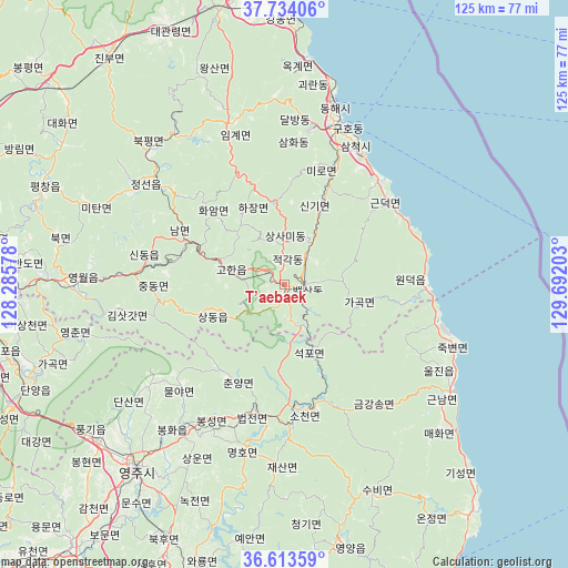
T’aebaek GPS coordinates[2]
37° 10' 33.24" North, 128° 59' 20.04" East
| Map corner | latitude | longitude |
|---|---|---|
| Upper-left | 37.73406°, | 128.28578° |
| Center: | 37.1759°, | 128.9889° |
| Lower-right: | 36.61359°, | 129.69203° |
| Map W x H: | 124.6×124.6 km | = 77.4×77.4mi |
| max Lat: | 38.37881° ⇑25.9% North |
| T’aebaek: | 37.1759° |
| min Lat: | ⇓74.1% South 33.25333° |
| min Long | T’aebaek | max Long |
| 126.10863° | 128.9889° | 129.55377° |
| W 92.7%⇐ | ⇒7.3% E |
Elevation
Elevation of T’aebaek is 691 m = 2267 ft, and this is 620.6 m = 2036 ft above average elevation for this country.
| Max E: |
691 m = 2267 ft | 0% |
| T’aebaek | 691 m 2267 ft | |
| Avg. | 70.4 m = 231 ft | |
Min E: |
1 m = 3 ft | 100% |
See also: T’aebaek elevation on elevation.city.
Geographical zone
T’aebaek is located in North temperate zone (between Tropic of Cancer and the Arctic Circle). Distance of this Northern Tropic circle is 1527.7 km =949.3 mi to South.| Distance of | km | miles | from T’aebaek |
|---|---|---|---|
| North Pole | 5873.5 | 3649.6 | to North |
| Arctic Circle | 3267.6 | 2030.4 | to North |
| Tropic Cancer | 1527.7 | 949.3 | to South |
| Equator | 4133.6 | 2568.5 | to South |


Nearby cities:
15 places around T’aebaek: (largest is in red/bold)
• Andong
71.8 km =44.6 mi,  199°
199°
• Cheongsong gun
82.8 km =51.4 mi,  175°
175°
• Eisen
50.6 km =31.4 mi,  218°
218°
• Gangdong
61.6 km =38.3 mi,  357°
357°
• Gangneung
64.9 km =40.3 mi,  350°
350°
• Gujeong
61.2 km =38 mi, 350°
• Mungyeong
92.3 km =57.4 mi,  237°
237°
• Neietsu
46.1 km =28.6 mi,  271°
271°
• Pyeongchang
57 km =35.4 mi,  292°
292°
• Santyoku
33.5 km =20.8 mi,  28°
28°
• Seoseok
92.5 km =57.5 mi,  310°
310°
• Tonghae
42.2 km =26.2 mi,  14°
14°
• Wŏnju
94.4 km =58.7 mi,  281°
281°
• Yecheon
74.7 km =46.4 mi, 219°
• Yeongdeok
91.3 km =56.7 mi,  158°
158°
Sources, notices
• [Note1] Compared only with cities in South Korea existing in our database
• [Src1] Map data: © OpenStreetMap contributors (CC-BY-SA)
• [Src2] Other city data from geonames.org with taken over terms of usage.
• [Src3] Geographical zone / Annual Mean Temperature by Robert A. Rohde @ Wikipedia
