Moyynty geodata
Moyynty (Karaganda) is a populated place; located in Kazakhstan in Asia/Almaty (GMT+5) time zone. With population of 2,049 people, there are 244 cities with bigger population in this country. Compared to other cities in Kazakhstan, 60% of cities are located further ↑North; 67.4% of cities are located further ←West and 81.1% of cities have lower elevation than Moyynty. Note1


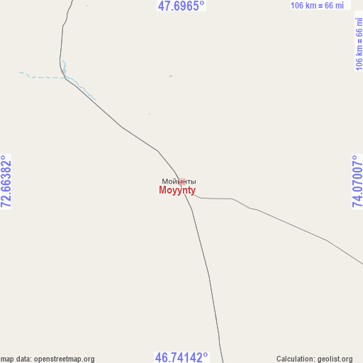
Moyynty GPS coordinates[2]
47° 13' 15.996" North, 73° 22' 0.984" East
| Map corner | latitude | longitude |
|---|---|---|
| Upper-left | 47.6965°, | 72.66382° |
| Center: | 47.22111°, | 73.36694° |
| Lower-right: | 46.74142°, | 74.07007° |
| Map W x H: | 106.2×106.2 km | = 66×66mi |
| max Lat: | 54.90596° ⇑60% North |
| Moyynty: | 47.22111° |
| min Lat: | ⇓40% South 40.66338° |
| min Long | Moyynty | max Long |
| 46.83361° | 73.36694° | 84.87144° |
| W 67.4%⇐ | ⇒32.6% E |
Elevation
Elevation of Moyynty is 575 m = 1886 ft, and this is 218.5 m = 717 ft above average elevation for this country.
| Max E: |
1847 m = 6060 ft | 18.9% |
| Moyynty | 575 m 1886 ft | |
| Avg. | 356.5 m = 1170 ft | |
Min E: |
-26 m = -85 ft | 81.1% |
See also: Kazakhstan elevation on elevation.city.
Geographical zone
Moyynty is located in North temperate zone (between Tropic of Cancer and the Arctic Circle). Distance of this North polar circle is 2150.7 km =1336.4 mi to North.| Distance of | km | miles | from Moyynty |
|---|---|---|---|
| North Pole | 4756.6 | 2955.6 | to North |
| Arctic Circle | 2150.7 | 1336.4 | to North |
| Tropic Cancer | 2644.6 | 1643.3 | to South |
| Equator | 5250.5 | 3262.5 | to South |


Nearby cities:
15 places around Moyynty: (largest is in red/bold)
• Aksu-Ayuly
173.5 km =107.8 mi,  7°
7°
• Aktau
98.8 km =61.4 mi,  336°
336°
• Aktogay
178.8 km =111.1 mi,  53°
53°
• Aqadyr
121.6 km =75.6 mi, 341°
• Aqshataū
99.9 km =62.1 mi,  31°
31°
• Atasū
207.4 km =128.9 mi,  321°
321°
• Balqash
130.2 km =80.9 mi,  108°
108°
• Gülshat
99.8 km =62 mi,  131°
131°
• Mynaral
202.2 km =125.6 mi,  173°
173°
• Priozersk
134.8 km =83.8 mi, 169°
• Saryshaghan
124 km =77.1 mi, 171°
• Shashūbay
134.6 km =83.6 mi, 109°
• Verkhniye Kayrakty
162.7 km =101.1 mi,  357°
357°
• Zhambyl
148.8 km =92.5 mi,  269°
269°
• Zharyk
186.1 km =115.6 mi,  347°
347°
Sources, notices
• [Note1] Compared only with cities in Kazakhstan existing in our database
• [Src1] Map data: © OpenStreetMap contributors (CC-BY-SA)
• [Src2] Other city data from geonames.org with taken over terms of usage.
• [Src3] Geographical zone / Annual Mean Temperature by Robert A. Rohde @ Wikipedia
