Qarazhal geodata
Qarazhal (Karaganda) is a populated place; located in Kazakhstan in Asia/Almaty (GMT+5) time zone. With population of 13,807 people, there are 86 cities with bigger population in this country. Compared to other cities in Kazakhstan, 55.6% of cities are located further ↑North; 52.6% of cities are located further ←West and 68.5% of cities have lower elevation than Qarazhal. Note1


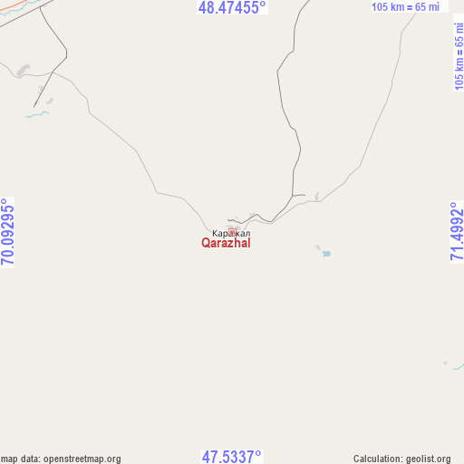
Qarazhal GPS coordinates[2]
48° 0' 22.572" North, 70° 47' 45.852" East
| Map corner | latitude | longitude |
|---|---|---|
| Upper-left | 48.47455°, | 70.09295° |
| Center: | 48.00627°, | 70.79607° |
| Lower-right: | 47.5337°, | 71.4992° |
| Map W x H: | 104.6×104.6 km | = 65×65mi |
| max Lat: | 54.90596° ⇑55.6% North |
| Qarazhal: | 48.00627° |
| min Lat: | ⇓44.4% South 40.66338° |
| min Long | Qarazhal | max Long |
| 46.83361° | 70.79607° | 84.87144° |
| W 52.6%⇐ | ⇒47.4% E |
Elevation
Elevation of Qarazhal is 468 m = 1535 ft, and this is 111.5 m = 366 ft above average elevation for this country.
| Max E: |
1847 m = 6060 ft | 31.5% |
| Qarazhal | 468 m 1535 ft | |
| Avg. | 356.5 m = 1170 ft | |
Min E: |
-26 m = -85 ft | 68.5% |
See also: Kazakhstan elevation on elevation.city.
Geographical zone
Qarazhal is located in North temperate zone (between Tropic of Cancer and the Arctic Circle). Distance of this North polar circle is 2063.4 km =1282.1 mi to North.| Distance of | km | miles | from Qarazhal |
|---|---|---|---|
| North Pole | 4669.3 | 2901.4 | to North |
| Arctic Circle | 2063.4 | 1282.1 | to North |
| Tropic Cancer | 2731.9 | 1697.5 | to South |
| Equator | 5337.8 | 3316.8 | to South |


Nearby cities:
15 places around Qarazhal: (largest is in red/bold)
• Abay
236 km =146.6 mi,  39°
39°
• Aksu-Ayuly
228.7 km =142.1 mi,  68°
68°
• Aktau
151.5 km =94.1 mi,  88°
88°
• Aqadyr
155.6 km =96.7 mi,  79°
79°
• Aqshataū
242.7 km =150.8 mi, 90°
• Atasū
98.3 km =61.1 mi, 39°
• Dolinka
231.2 km =143.7 mi, 36°
• Moyynty
211.5 km =131.4 mi,  114°
114°
• Novodolinskiy
235.2 km =146.1 mi, 36°
• Shakhtinsk
230.4 km =143.2 mi,  34°
34°
• Shubarköl
176.1 km =109.4 mi,  303°
303°
• Verkhniye Kayrakty
198.6 km =123.4 mi, 67°
• Zhambyl
99.6 km =61.9 mi,  153°
153°
• Zharyk
177.7 km =110.4 mi,  57°
57°
• Zhezqazghan
227.2 km =141.2 mi,  263°
263°
Sources, notices
• [Note1] Compared only with cities in Kazakhstan existing in our database
• [Src1] Map data: © OpenStreetMap contributors (CC-BY-SA)
• [Src2] Other city data from geonames.org with taken over terms of usage.
• [Src3] Geographical zone / Annual Mean Temperature by Robert A. Rohde @ Wikipedia
