Muang Phônsavan geodata
Muang Phônsavan (Xiangkhoang) is a seat of a first-order administrative division; located in Laos in Asia/Vientiane (GMT+7) time zone. With population of 37,507 people, there are 6 cities with bigger population in this country. Compared to other cities in Laos, 63.5% of cities are located further ↓South; 61.5% of cities are located further →East and 88.5% of cities have lower elevation than Muang Phônsavan. Note1


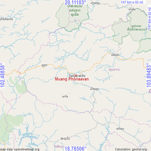
Muang Phônsavan GPS coordinates[2]
19° 26' 57.84" North, 103° 11' 30.12" East
| Map corner | latitude | longitude |
|---|---|---|
| Upper-left | 20.11103°, | 102.48858° |
| Center: | 19.4494°, | 103.1917° |
| Lower-right: | 18.78506°, | 103.89483° |
| Map W x H: | 147.4×147.4 km | = 91.6×91.6mi |
| max Lat: | 21.6808° ⇑36.5% North |
| Muang Phônsavan: | 19.4494° |
| min Lat: | ⇓63.5% South 14.11785° |
| min Long | Muang Phônsava | max Long |
| 100.4178° | 103.1917° | 107.26667° |
| W 38.5%⇐ | ⇒61.5% E |
Elevation
Elevation of Muang Phônsavan is 1119 m = 3671 ft, and this is 645.4 m = 2117 ft above average elevation for this country.
| Max E: |
1722 m = 5650 ft | 11.5% |
| Muang Phônsavan | 1119 m 3671 ft | |
| Avg. | 473.6 m = 1554 ft | |
Min E: |
83 m = 272 ft | 88.5% |
See also: Laos elevation on elevation.city.
Geographical zone
Muang Phônsavan is located in North Torrid zone (between Equator and Tropic of Cancer). Distance of this Northern Tropic circle is 443.3 km =275.5 mi to North.| Distance of | km | miles | from Muang Phônsavan |
|---|---|---|---|
| North Pole | 7844.5 | 4874.3 | to North |
| Arctic Circle | 5238.6 | 3255.1 | to North |
| Tropic Cancer | 443.3 | 275.5 | to North |
| Equator | 2162.6 | 1343.8 | to South |


Nearby cities:
15 places around Muang Phônsavan: (largest is in red/bold)
• Ban Xiang-Ngeun
111.2 km =69.1 mi,  288°
288°
• Borikhan
113.5 km =70.5 mi,  150°
150°
• Huameung
104.5 km =64.9 mi,  41°
41°
• Luang Prabang
120.8 km =75.1 mi, 293°
• Muang Kasi
101.5 km =63.1 mi,  256°
256°
• Muang Mok
104.5 km =64.9 mi,  125°
125°
• Muang Phôn-Hông
133.9 km =83.2 mi,  217°
217°
• Pakkading
150.9 km =93.8 mi, 145°
• Pakxan
127.3 km =79.1 mi,  157°
157°
• Vangviang
97.6 km =60.6 mi,  233°
233°
• Viangxai
151.6 km =94.2 mi,  45°
45°
• Viengthong
100.3 km =62.3 mi,  13°
13°
• Viengxay
156.2 km =97.1 mi, 50°
• Xam Nua
139.7 km =86.8 mi, 39°
• Xamtay
149.3 km =92.8 mi,  68°
68°
Sources, notices
• [Note1] Compared only with cities in Laos existing in our database
• [Src1] Map data: © OpenStreetMap contributors (CC-BY-SA)
• [Src2] Other city data from geonames.org with taken over terms of usage.
• [Src3] Geographical zone / Annual Mean Temperature by Robert A. Rohde @ Wikipedia
