Viangxai geodata
Viangxai (Houaphan) is a seat of a second-order administrative division; located in Laos in Asia/Vientiane (GMT+7) time zone. In our database, there are 24 cities with bigger population. Compared to other cities in Laos, 80.8% of cities are located further ↓South; 55.8% of cities are located further ←West and 80.8% of cities have lower elevation than Viangxai. Note1


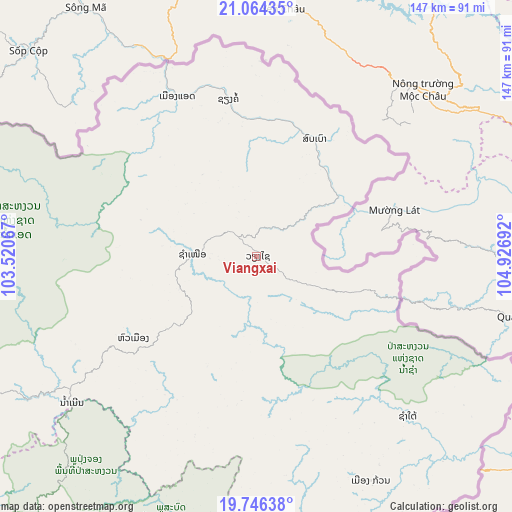
Viangxai GPS coordinates[2]
20° 24' 24.372" North, 104° 13' 25.644" East
| Map corner | latitude | longitude |
|---|---|---|
| Upper-left | 21.06435°, | 103.52067° |
| Center: | 20.40677°, | 104.22379° |
| Lower-right: | 19.74638°, | 104.92692° |
| Map W x H: | 146.5×146.5 km | = 91×91mi |
| max Lat: | 21.6808° ⇑19.2% North |
| Viangxai: | 20.40677° |
| min Lat: | ⇓80.8% South 14.11785° |
| min Long | Viangxai | max Long |
| 100.4178° | 104.22379° | 107.26667° |
| W 55.8%⇐ | ⇒44.2% E |
Elevation
Elevation of Viangxai is 882 m = 2894 ft, and this is 408.4 m = 1340 ft above average elevation for this country.
| Max E: |
1722 m = 5650 ft | 19.2% |
| Viangxai | 882 m 2894 ft | |
| Avg. | 473.6 m = 1554 ft | |
Min E: |
83 m = 272 ft | 80.8% |
See also: Laos elevation on elevation.city.
Geographical zone
Viangxai is located in North Torrid zone (between Equator and Tropic of Cancer). Distance of this Northern Tropic circle is 336.9 km =209.3 mi to North.| Distance of | km | miles | from Viangxai |
|---|---|---|---|
| North Pole | 7738 | 4808.2 | to North |
| Arctic Circle | 5132.2 | 3189 | to North |
| Tropic Cancer | 336.9 | 209.3 | to North |
| Equator | 2269 | 1409.9 | to South |


Nearby cities:
15 places around Viangxai: (largest is in red/bold)
• Ban Namnga
177.5 km =110.3 mi,  298°
298°
• Ban Pakla
225.7 km =140.2 mi,  283°
283°
• Ban Xiang-Ngeun
225 km =139.8 mi,  251°
251°
• Borikhan
211.5 km =131.4 mi,  194°
194°
• Huameung
47.6 km =29.6 mi,  233°
233°
• Khoa
193.6 km =120.3 mi,  292°
292°
• Luang Prabang
225.6 km =140.2 mi,  255°
255°
• Muang Mok
168 km =104.4 mi, 187°
• Muang Phônsavan
151.6 km =94.2 mi, 225°
• Pakkading
232.8 km =144.7 mi, 185°
• Pakxan
231.4 km =143.8 mi, 194°
• Viengthong
85.4 km =53.1 mi, 264°
• Viengxay
14.5 km =9 mi,  119°
119°
• Xam Nua
18.7 km =11.6 mi,  273°
273°
• Xamtay
59.8 km =37.2 mi,  149°
149°
Sources, notices
• [Note1] Compared only with cities in Laos existing in our database
• [Src1] Map data: © OpenStreetMap contributors (CC-BY-SA)
• [Src2] Other city data from geonames.org with taken over terms of usage.
• [Src3] Geographical zone / Annual Mean Temperature by Robert A. Rohde @ Wikipedia
