Ratnapura geodata
Ratnapura (Sabaragamuwa) is a seat of a first-order administrative division; located in Sri Lanka in Asia/Colombo (GMT+5.5) time zone. With population of 47,832 people, there are 24 cities with bigger population in this country. Compared to other cities in Sri Lanka, 78.9% of cities are located further ↑North; 57.9% of cities are located further ←West and 78.9% of cities have lower elevation than Ratnapura. Note1


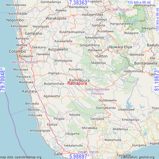
Ratnapura GPS coordinates[2]
6° 41' 8.88" North, 80° 24' 12.96" East
| Map corner | latitude | longitude |
|---|---|---|
| Upper-left | 7.38363°, | 79.70048° |
| Center: | 6.6858°, | 80.4036° |
| Lower-right: | 5.98697°, | 81.10673° |
| Map W x H: | 155.3×155.3 km | = 96.5×96.5mi |
| max Lat: | 9.81667° ⇑78.9% North |
| Ratnapura: | 6.6858° |
| min Lat: | ⇓21.1% South 5.92825° |
| min Long | Ratnapura | max Long |
| 79.79528° | 80.4036° | 81.83472° |
| W 57.9%⇐ | ⇒42.1% E |
Elevation
Elevation of Ratnapura is 149 m = 489 ft, and this is 8.4 m = 28 ft below average elevation for this country.
| Max E: |
1868 m = 6129 ft | 21.1% |
| Avg. | 157.4 m = 516 ft | |
| Ratnapura | 149 m = 489 ft | |
Min E: |
1 m = 3 ft | 78.9% |
See also: Ratnapura elevation on elevation.city.
Geographical zone
Ratnapura is located in North Torrid zone (between Equator and Tropic of Cancer). Distance of Equator is 743.4 km =461.9 mi to South.| Distance of | km | miles | from Ratnapura |
|---|---|---|---|
| North Pole | 9263.7 | 5756.2 | to North |
| Arctic Circle | 6657.8 | 4137 | to North |
| Tropic Cancer | 1862.5 | 1157.3 | to North |
| Equator | 743.4 | 461.9 | to South |


Nearby cities:
15 places around Ratnapura: (largest is in red/bold)
• Battaramulla South
58.5 km =36.4 mi,  293°
293°
• Bentota
53.5 km =33.2 mi,  237°
237°
• Beruwala
51.9 km =32.2 mi, 243°
• Gampola
56.3 km =35 mi,  19°
19°
• Hanwella Ihala
42.5 km =26.4 mi,  304°
304°
• Hatton
31.2 km =19.4 mi,  42°
42°
• Homagama
47.7 km =29.6 mi, 291°
• Horana South
37.8 km =23.5 mi,  275°
275°
• Horawala Junction
38.1 km =23.7 mi,  233°
233°
• Kalutara
50.4 km =31.3 mi,  256°
256°
• Maharagama
55.7 km =34.6 mi, 288°
• Moratuwa
58.5 km =36.4 mi, 279°
• Nuwara Eliya
52.5 km =32.6 mi,  52°
52°
• Panadura
55.4 km =34.4 mi,  273°
273°
• Talawakele
39.6 km =24.6 mi, 45°
Sources, notices
• [Note1] Compared only with cities in Sri Lanka existing in our database
• [Src1] Map data: © OpenStreetMap contributors (CC-BY-SA)
• [Src2] Other city data from geonames.org with taken over terms of usage.
• [Src3] Geographical zone / Annual Mean Temperature by Robert A. Rohde @ Wikipedia
