Vavuniya geodata
Vavuniya (Northern Province) is a populated place; located in Sri Lanka in Asia/Colombo (GMT+5.5) time zone. With population of 60,176 people, there are 21 cities with bigger population in this country. Compared to other cities in Sri Lanka, 93.4% of cities are located further ↓South; 63.2% of cities are located further ←West and 75% of cities have lower elevation than Vavuniya. Note1
Administrative division(s):
- Level 1: Northern Province
- Level 2: Vavuniya District
- Level 3: Vavuniya
- Level 4: Vavuniya Town


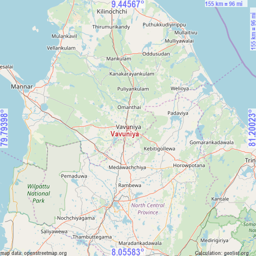
Vavuniya GPS coordinates[2]
8° 45' 5.04" North, 80° 29' 49.56" East
| Map corner | latitude | longitude |
|---|---|---|
| Upper-left | 9.44567°, | 79.79398° |
| Center: | 8.7514°, | 80.4971° |
| Lower-right: | 8.05583°, | 81.20023° |
| Map W x H: | 154.5×154.5 km | = 96×96mi |
| max Lat: | 9.81667° ⇑6.6% North |
| Vavuniya: | 8.7514° |
| min Lat: | ⇓93.4% South 5.92825° |
| min Long | Vavuniya | max Long |
| 79.79528° | 80.4971° | 81.83472° |
| W 63.2%⇐ | ⇒36.8% E |
Elevation
Elevation of Vavuniya is 104 m = 341 ft, and this is 53.4 m = 175 ft below average elevation for this country.
| Max E: |
1868 m = 6129 ft | 25% |
| Avg. | 157.4 m = 516 ft | |
| Vavuniya | 104 m = 341 ft | |
Min E: |
1 m = 3 ft | 75% |
See also: Vavuniya elevation on elevation.city.
Geographical zone
Vavuniya is located in North Torrid zone (between Equator and Tropic of Cancer). Distance of Equator is 973.1 km =604.7 mi to South.| Distance of | km | miles | from Vavuniya |
|---|---|---|---|
| North Pole | 9034 | 5613.5 | to North |
| Arctic Circle | 6428.1 | 3994.2 | to North |
| Tropic Cancer | 1632.9 | 1014.6 | to North |
| Equator | 973.1 | 604.7 | to South |


Nearby cities:
15 places around Vavuniya: (largest is in red/bold)
• Anuradhapura
49.7 km =30.9 mi,  190°
190°
• Dambulla
100.6 km =62.5 mi,  170°
170°
• Jaffna
115.3 km =71.6 mi,  332°
332°
• Kilinochchi
72.5 km =45 mi,  351°
351°
• Kurunegala
141.6 km =88 mi, 185°
• Matale
143.2 km =89 mi, 174°
• Mihintale
43.6 km =27.1 mi,  178°
178°
• Padaviya Divisional Secretariat
31 km =19.3 mi,  70°
70°
• Point Pedro
121.9 km =75.7 mi, 346°
• Polonnaruwa
106 km =65.9 mi,  148°
148°
• Puttalam
108.3 km =67.3 mi,  222°
222°
• Sigiriya
93.4 km =58 mi,  162°
162°
• Trincomalee
82.7 km =51.4 mi,  103°
103°
• Vakarai
123.8 km =76.9 mi,  123°
123°
• Valvedditturai
123.9 km =77 mi,  342°
342°
Sources, notices
• [Note1] Compared only with cities in Sri Lanka existing in our database
• [Src1] Map data: © OpenStreetMap contributors (CC-BY-SA)
• [Src2] Other city data from geonames.org with taken over terms of usage.
• [Src3] Geographical zone / Annual Mean Temperature by Robert A. Rohde @ Wikipedia
