Matale geodata
Matale (Central) is a populated place; located in Sri Lanka in Asia/Colombo (GMT+5.5) time zone. With population of 36,462 people, there are 31 cities with bigger population in this country. Compared to other cities in Sri Lanka, 76.3% of cities are located further ↓South; 72.4% of cities are located further ←West and 88.2% of cities have lower elevation than Matale. Note1


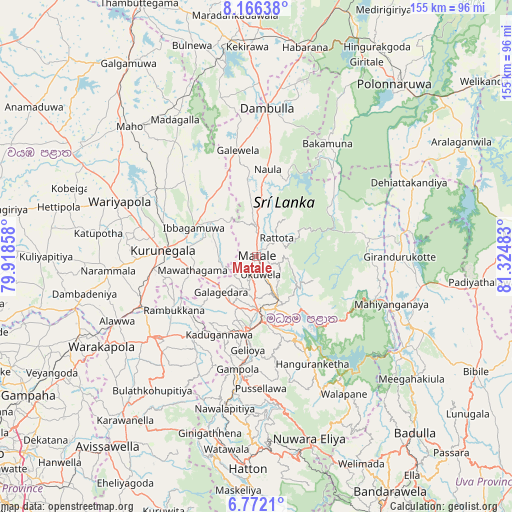
Matale GPS coordinates[2]
7° 28' 11.28" North, 80° 37' 18.12" East
| Map corner | latitude | longitude |
|---|---|---|
| Upper-left | 8.16638°, | 79.91858° |
| Center: | 7.4698°, | 80.6217° |
| Lower-right: | 6.7721°, | 81.32483° |
| Map W x H: | 155×155 km | = 96.3×96.3mi |
| max Lat: | 9.81667° ⇑23.7% North |
| Matale: | 7.4698° |
| min Lat: | ⇓76.3% South 5.92825° |
| min Long | Matale | max Long |
| 79.79528° | 80.6217° | 81.83472° |
| W 72.4%⇐ | ⇒27.6% E |
Elevation
Elevation of Matale is 366 m = 1201 ft, and this is 208.6 m = 684 ft above average elevation for this country.
| Max E: |
1868 m = 6129 ft | 11.8% |
| Matale | 366 m 1201 ft | |
| Avg. | 157.4 m = 516 ft | |
Min E: |
1 m = 3 ft | 88.2% |
See also: Sri Lanka elevation on elevation.city.
Geographical zone
Matale is located in North Torrid zone (between Equator and Tropic of Cancer). Distance of Equator is 830.6 km =516.1 mi to South.| Distance of | km | miles | from Matale |
|---|---|---|---|
| North Pole | 9176.5 | 5702 | to North |
| Arctic Circle | 6570.6 | 4082.8 | to North |
| Tropic Cancer | 1775.4 | 1103.2 | to North |
| Equator | 830.6 | 516.1 | to South |


Nearby cities:
15 places around Matale: (largest is in red/bold)
• Badulla
72.6 km =45.1 mi,  138°
138°
• Dambulla
43.5 km =27 mi,  4°
4°
• Ella Town
81 km =50.3 mi, 144°
• Gampola
34.5 km =21.4 mi,  189°
189°
• Hatton
64.4 km =40 mi,  182°
182°
• Kadugannawa
26.2 km =16.3 mi,  204°
204°
• Kandy
20 km =12.4 mi, 176°
• Kegalle
39.1 km =24.3 mi,  231°
231°
• Kuliyapitiya
64.1 km =39.8 mi,  269°
269°
• Kurunegala
28 km =17.4 mi, 273°
• Minuwangoda
81.1 km =50.4 mi,  245°
245°
• Nuwara Eliya
58.3 km =36.2 mi,  162°
162°
• Polonnaruwa
67 km =41.6 mi,  38°
38°
• Sigiriya
55.2 km =34.3 mi,  14°
14°
• Talawakele
59.4 km =36.9 mi, 176°
Sources, notices
• [Note1] Compared only with cities in Sri Lanka existing in our database
• [Src1] Map data: © OpenStreetMap contributors (CC-BY-SA)
• [Src2] Other city data from geonames.org with taken over terms of usage.
• [Src3] Geographical zone / Annual Mean Temperature by Robert A. Rohde @ Wikipedia
