Vakarai geodata
Vakarai (Eastern Province) is a populated place; located in Sri Lanka in Asia/Colombo (GMT+5.5) time zone. With population of 21,000 people, there are 48 cities with bigger population in this country. Compared to other cities in Sri Lanka, 88.2% of cities are located further ↓South; 93.4% of cities are located further ←West and 78.9% of cities have higher elevation than Vakarai. Note1
Administrative division(s):
- Level 1: Eastern Province
- Level 2: Batticaloa District
- Level 3: Koralai Pattu Nort
- Level 4: Vakarai Central


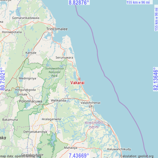
Vakarai GPS coordinates[2]
8° 7' 59.988" North, 81° 25' 59.988" East
| Map corner | latitude | longitude |
|---|---|---|
| Upper-left | 8.82876°, | 80.73021° |
| Center: | 8.13333°, | 81.43333° |
| Lower-right: | 7.43669°, | 82.13646° |
| Map W x H: | 154.8×154.8 km | = 96.2×96.2mi |
| max Lat: | 9.81667° ⇑11.8% North |
| Vakarai: | 8.13333° |
| min Lat: | ⇓88.2% South 5.92825° |
| min Long | Vakarai | max Long |
| 79.79528° | 81.43333° | 81.83472° |
| W 93.4%⇐ | ⇒6.6% E |
Elevation
Elevation of Vakarai is 9 m = 30 ft, and this is 148.4 m = 487 ft below average elevation for this country.
| Max E: |
1868 m = 6129 ft | 78.9% |
| Avg. | 157.4 m = 516 ft | |
| Vakarai | 9 m = 30 ft | |
Min E: |
1 m = 3 ft | 21.1% |
See also: Sri Lanka elevation on elevation.city.
Geographical zone
Vakarai is located in North Torrid zone (between Equator and Tropic of Cancer). Distance of Equator is 904.3 km =561.9 mi to South.| Distance of | km | miles | from Vakarai |
|---|---|---|---|
| North Pole | 9102.7 | 5656.2 | to North |
| Arctic Circle | 6496.8 | 4036.9 | to North |
| Tropic Cancer | 1701.6 | 1057.3 | to North |
| Equator | 904.3 | 561.9 | to South |


Nearby cities:
15 places around Vakarai: (largest is in red/bold)
• Ampara
96.9 km =60.2 mi,  163°
163°
• Anuradhapura
114 km =70.8 mi,  280°
280°
• Badulla
134.7 km =83.7 mi,  197°
197°
• Batticaloa
55 km =34.2 mi,  148°
148°
• Dambulla
91.3 km =56.7 mi,  250°
250°
• Eravur Town
43.7 km =27.2 mi, 154°
• Kalmunai
91.9 km =57.1 mi, 151°
• Kandy
128.6 km =79.9 mi,  223°
223°
• Matale
115.9 km =72 mi,  230°
230°
• Mihintale
104.6 km =65 mi, 283°
• Padaviya Divisional Secretariat
108.2 km =67.2 mi,  317°
317°
• Polonnaruwa
52.1 km =32.4 mi, 245°
• Sigiriya
77.9 km =48.4 mi, 254°
• Trincomalee
54.3 km =33.7 mi,  335°
335°
• Vavuniya
123.8 km =76.9 mi,  303°
303°
Sources, notices
• [Note1] Compared only with cities in Sri Lanka existing in our database
• [Src1] Map data: © OpenStreetMap contributors (CC-BY-SA)
• [Src2] Other city data from geonames.org with taken over terms of usage.
• [Src3] Geographical zone / Annual Mean Temperature by Robert A. Rohde @ Wikipedia
