Polonnaruwa geodata
Polonnaruwa (North Central) is a populated place; located in Sri Lanka in Asia/Colombo (GMT+5.5) time zone. With population of 13,900 people, there are 54 cities with bigger population in this country. Compared to other cities in Sri Lanka, 84.2% of cities are located further ↓South; 84.2% of cities are located further ←West and 72.4% of cities have lower elevation than Polonnaruwa. Note1
Administrative division(s):
- Level 1: North Central
- Level 2: Polonnaruwa District
- Level 3: Thamankaduwa
- Level 4: Polonnaruwa Town


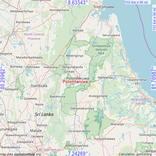
Polonnaruwa GPS coordinates[2]
7° 56' 22.74" North, 81° 0' 9.864" East
| Map corner | latitude | longitude |
|---|---|---|
| Upper-left | 8.63543°, | 80.29962° |
| Center: | 7.93965°, | 81.00274° |
| Lower-right: | 7.24269°, | 81.70587° |
| Map W x H: | 154.9×154.9 km | = 96.3×96.3mi |
| max Lat: | 9.81667° ⇑15.8% North |
| Polonnaruwa: | 7.93965° |
| min Lat: | ⇓84.2% South 5.92825° |
| min Long | Polonnaruwa | max Long |
| 79.79528° | 81.00274° | 81.83472° |
| W 84.2%⇐ | ⇒15.8% E |
Elevation
Elevation of Polonnaruwa is 60 m = 197 ft, and this is 97.4 m = 320 ft below average elevation for this country.
| Max E: |
1868 m = 6129 ft | 27.6% |
| Avg. | 157.4 m = 516 ft | |
| Polonnaruwa | 60 m = 197 ft | |
Min E: |
1 m = 3 ft | 72.4% |
See also: Sri Lanka elevation on elevation.city.
Geographical zone
Polonnaruwa is located in North Torrid zone (between Equator and Tropic of Cancer). Distance of Equator is 882.8 km =548.5 mi to South.| Distance of | km | miles | from Polonnaruwa |
|---|---|---|---|
| North Pole | 9124.3 | 5669.6 | to North |
| Arctic Circle | 6518.4 | 4050.3 | to North |
| Tropic Cancer | 1723.1 | 1070.7 | to North |
| Equator | 882.8 | 548.5 | to South |


Nearby cities:
15 places around Polonnaruwa: (largest is in red/bold)
• Ampara
103.4 km =64.2 mi,  133°
133°
• Anuradhapura
77 km =47.8 mi,  302°
302°
• Batticaloa
80.1 km =49.8 mi,  108°
108°
• Dambulla
39.7 km =24.7 mi,  257°
257°
• Eravur Town
68.6 km =42.6 mi, 105°
• Gampola
98.5 km =61.2 mi,  208°
208°
• Kadugannawa
92.6 km =57.5 mi, 214°
• Kandy
82.8 km =51.4 mi, 209°
• Kurunegala
86.3 km =53.6 mi,  234°
234°
• Matale
67 km =41.6 mi,  218°
218°
• Mihintale
71.5 km =44.4 mi,  310°
310°
• Padaviya Divisional Secretariat
104.1 km =64.7 mi,  345°
345°
• Sigiriya
27.8 km =17.3 mi,  272°
272°
• Trincomalee
75.2 km =46.7 mi,  19°
19°
• Vakarai
52.1 km =32.4 mi,  65°
65°
Sources, notices
• [Note1] Compared only with cities in Sri Lanka existing in our database
• [Src1] Map data: © OpenStreetMap contributors (CC-BY-SA)
• [Src2] Other city data from geonames.org with taken over terms of usage.
• [Src3] Geographical zone / Annual Mean Temperature by Robert A. Rohde @ Wikipedia
