Kurunegala geodata
Kurunegala (North Western) is a seat of a first-order administrative division; located in Sri Lanka in Asia/Colombo (GMT+5.5) time zone. With population of 28,571 people, there are 41 cities with bigger population in this country. Compared to other cities in Sri Lanka, 77.6% of cities are located further ↓South; 55.3% of cities are located further ←West and 84.2% of cities have lower elevation than Kurunegala. Note1


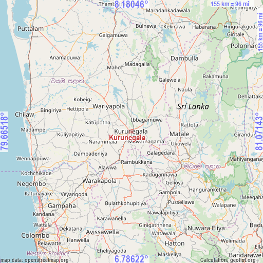
Kurunegala GPS coordinates[2]
7° 29' 2.04" North, 80° 22' 5.88" East
| Map corner | latitude | longitude |
|---|---|---|
| Upper-left | 8.18046°, | 79.66518° |
| Center: | 7.4839°, | 80.3683° |
| Lower-right: | 6.78622°, | 81.07143° |
| Map W x H: | 155×155 km | = 96.3×96.3mi |
| max Lat: | 9.81667° ⇑22.4% North |
| Kurunegala: | 7.4839° |
| min Lat: | ⇓77.6% South 5.92825° |
| min Long | Kurunegala | max Long |
| 79.79528° | 80.3683° | 81.83472° |
| W 55.3%⇐ | ⇒44.7% E |
Elevation
Elevation of Kurunegala is 186 m = 610 ft, and this is 28.6 m = 94 ft above average elevation for this country.
| Max E: |
1868 m = 6129 ft | 15.8% |
| Kurunegala | 186 m 610 ft | |
| Avg. | 157.4 m = 516 ft | |
Min E: |
1 m = 3 ft | 84.2% |
See also: Sri Lanka elevation on elevation.city.
Geographical zone
Kurunegala is located in North Torrid zone (between Equator and Tropic of Cancer). Distance of Equator is 832.1 km =517 mi to South.| Distance of | km | miles | from Kurunegala |
|---|---|---|---|
| North Pole | 9174.9 | 5701 | to North |
| Arctic Circle | 6569 | 4081.8 | to North |
| Tropic Cancer | 1773.8 | 1102.2 | to North |
| Equator | 832.1 | 517 | to South |


Nearby cities:
15 places around Kurunegala: (largest is in red/bold)
• Chilaw
64 km =39.8 mi,  279°
279°
• Dambulla
52.2 km =32.4 mi,  36°
36°
• Gampaha
60.3 km =37.5 mi,  223°
223°
• Gampola
41.9 km =26 mi,  148°
148°
• Ja Ela
69.5 km =43.2 mi,  229°
229°
• Kadugannawa
30.7 km =19.1 mi, 145°
• Kandy
36.3 km =22.6 mi,  126°
126°
• Katunayaka
63.4 km =39.4 mi,  236°
236°
• Kegalle
25.9 km =16.1 mi,  186°
186°
• Kuliyapitiya
36.2 km =22.5 mi,  267°
267°
• Matale
28 km =17.4 mi,  93°
93°
• Minuwangoda
57.8 km =35.9 mi, 232°
• Negombo
66.2 km =41.1 mi, 242°
• Sigiriya
66.7 km =41.4 mi, 39°
• Talawakele
68.7 km =42.7 mi, 152°
Sources, notices
• [Note1] Compared only with cities in Sri Lanka existing in our database
• [Src1] Map data: © OpenStreetMap contributors (CC-BY-SA)
• [Src2] Other city data from geonames.org with taken over terms of usage.
• [Src3] Geographical zone / Annual Mean Temperature by Robert A. Rohde @ Wikipedia
