Dambulla geodata
Dambulla (Central) is a populated place; located in Sri Lanka in Asia/Colombo (GMT+5.5) time zone. With population of 66,716 people, there are 17 cities with bigger population in this country. Compared to other cities in Sri Lanka, 82.9% of cities are located further ↓South; 75% of cities are located further ←West and 81.6% of cities have lower elevation than Dambulla. Note1
Administrative division(s):
- Level 1: Central
- Level 2: Matale District
- Level 3: Dambulla
- Level 4: Dambulla Town


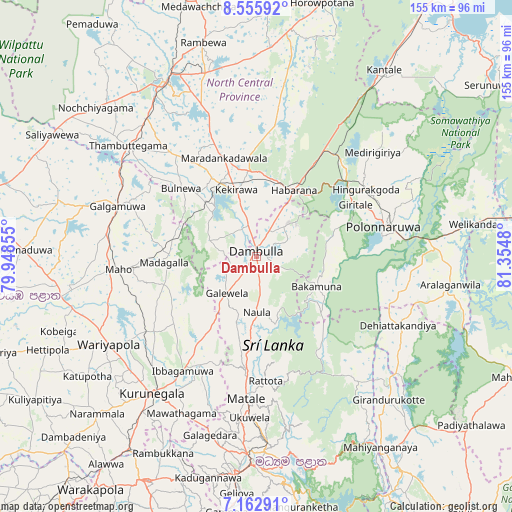
Dambulla GPS coordinates[2]
7° 51' 36" North, 80° 39' 6.012" East
| Map corner | latitude | longitude |
|---|---|---|
| Upper-left | 8.55592°, | 79.94855° |
| Center: | 7.86°, | 80.65167° |
| Lower-right: | 7.16291°, | 81.3548° |
| Map W x H: | 154.9×154.9 km | = 96.3×96.3mi |
| max Lat: | 9.81667° ⇑17.1% North |
| Dambulla: | 7.86° |
| min Lat: | ⇓82.9% South 5.92825° |
| min Long | Dambulla | max Long |
| 79.79528° | 80.65167° | 81.83472° |
| W 75%⇐ | ⇒25% E |
Elevation
Elevation of Dambulla is 168 m = 551 ft, and this is 10.6 m = 35 ft above average elevation for this country.
| Max E: |
1868 m = 6129 ft | 18.4% |
| Dambulla | 168 m 551 ft | |
| Avg. | 157.4 m = 516 ft | |
Min E: |
1 m = 3 ft | 81.6% |
See also: Dambulla elevation on elevation.city.
Geographical zone
Dambulla is located in North Torrid zone (between Equator and Tropic of Cancer). Distance of Equator is 874 km =543.1 mi to South.| Distance of | km | miles | from Dambulla |
|---|---|---|---|
| North Pole | 9133.1 | 5675 | to North |
| Arctic Circle | 6527.2 | 4055.8 | to North |
| Tropic Cancer | 1732 | 1076.2 | to North |
| Equator | 874 | 543.1 | to South |


Nearby cities:
15 places around Dambulla: (largest is in red/bold)
• Anuradhapura
56.7 km =35.2 mi,  332°
332°
• Chilaw
99.5 km =61.8 mi,  251°
251°
• Gampola
77.9 km =48.4 mi,  186°
186°
• Kadugannawa
68.8 km =42.8 mi, 191°
• Kandy
63.3 km =39.3 mi,  181°
181°
• Kegalle
75.6 km =47 mi,  206°
206°
• Kuliyapitiya
80.2 km =49.8 mi,  237°
237°
• Kurunegala
52.2 km =32.4 mi,  216°
216°
• Matale
43.5 km =27 mi, 184°
• Mihintale
57.7 km =35.9 mi,  344°
344°
• Nuwara Eliya
99.9 km =62.1 mi,  171°
171°
• Polonnaruwa
39.7 km =24.7 mi,  77°
77°
• Puttalam
92.8 km =57.7 mi,  282°
282°
• Sigiriya
14.7 km =9.1 mi,  47°
47°
• Vakarai
91.3 km =56.7 mi,  70°
70°
Sources, notices
• [Note1] Compared only with cities in Sri Lanka existing in our database
• [Src1] Map data: © OpenStreetMap contributors (CC-BY-SA)
• [Src2] Other city data from geonames.org with taken over terms of usage.
• [Src3] Geographical zone / Annual Mean Temperature by Robert A. Rohde @ Wikipedia
