Puttalam geodata
Puttalam (North Western) is a populated place; located in Sri Lanka in Asia/Colombo (GMT+5.5) time zone. With population of 45,661 people, there are 26 cities with bigger population in this country. Compared to other cities in Sri Lanka, 86.8% of cities are located further ↓South; 98.7% of cities are located further →East and 88.2% of cities have higher elevation than Puttalam. Note1
Administrative division(s):
- Level 1: North Western
- Level 2: Puttalam District
- Level 3: Puttalam Division


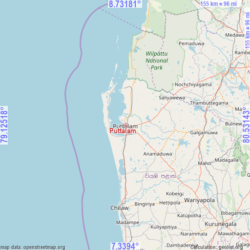
Puttalam GPS coordinates[2]
8° 2' 10.32" North, 79° 49' 41.88" East
| Map corner | latitude | longitude |
|---|---|---|
| Upper-left | 8.73181°, | 79.12518° |
| Center: | 8.0362°, | 79.8283° |
| Lower-right: | 7.3394°, | 80.53143° |
| Map W x H: | 154.8×154.8 km | = 96.2×96.2mi |
| max Lat: | 9.81667° ⇑13.2% North |
| Puttalam: | 8.0362° |
| min Lat: | ⇓86.8% South 5.92825° |
| min Long | Puttalam | max Long |
| 79.79528° | 79.8283° | 81.83472° |
| W 1.3%⇐ | ⇒98.7% E |
Elevation
Elevation of Puttalam is 8 m = 26 ft, and this is 149.4 m = 490 ft below average elevation for this country.
| Max E: |
1868 m = 6129 ft | 88.2% |
| Avg. | 157.4 m = 516 ft | |
| Puttalam | 8 m = 26 ft | |
Min E: |
1 m = 3 ft | 11.8% |
See also: Puttalam elevation on elevation.city.
Geographical zone
Puttalam is located in North Torrid zone (between Equator and Tropic of Cancer). Distance of Equator is 893.5 km =555.2 mi to South.| Distance of | km | miles | from Puttalam |
|---|---|---|---|
| North Pole | 9113.5 | 5662.9 | to North |
| Arctic Circle | 6507.6 | 4043.6 | to North |
| Tropic Cancer | 1712.4 | 1064 | to North |
| Equator | 893.5 | 555.2 | to South |


Nearby cities:
15 places around Puttalam: (largest is in red/bold)
• Anuradhapura
71.3 km =44.3 mi,  64°
64°
• Chilaw
51.3 km =31.9 mi,  184°
184°
• Dambulla
92.8 km =57.7 mi,  102°
102°
• Gampaha
106.8 km =66.4 mi,  170°
170°
• Ja Ela
107.2 km =66.6 mi, 176°
• Katunayaka
96.5 km =60 mi, 176°
• Kegalle
104 km =64.6 mi,  146°
146°
• Kuliyapitiya
67.3 km =41.8 mi,  159°
159°
• Kurunegala
85.5 km =53.1 mi,  135°
135°
• Matale
107.7 km =66.9 mi,  125°
125°
• Mihintale
83.2 km =51.7 mi, 64°
• Minuwangoda
97.7 km =60.7 mi, 171°
• Negombo
92.1 km =57.2 mi, 179°
• Sigiriya
102 km =63.4 mi, 95°
• Vavuniya
108.3 km =67.3 mi,  42°
42°
Sources, notices
• [Note1] Compared only with cities in Sri Lanka existing in our database
• [Src1] Map data: © OpenStreetMap contributors (CC-BY-SA)
• [Src2] Other city data from geonames.org with taken over terms of usage.
• [Src3] Geographical zone / Annual Mean Temperature by Robert A. Rohde @ Wikipedia
