Hatton geodata
Hatton (Central) is a populated place; located in Sri Lanka in Asia/Colombo (GMT+5.5) time zone. With population of 15,073 people, there are 53 cities with bigger population in this country. Compared to other cities in Sri Lanka, 60.5% of cities are located further ↑North; 71.1% of cities are located further ←West and 97.4% of cities have lower elevation than Hatton. Note1
Administrative division(s):
- Level 1: Central
- Level 2: Nuwara Eliya District
- Level 3: Ambagamuwa Division
- Level 4: Hatton South


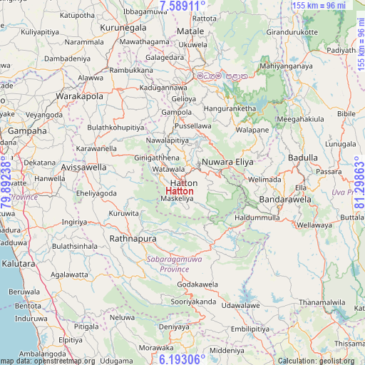
Hatton GPS coordinates[2]
6° 53' 29.76" North, 80° 35' 43.8" East
| Map corner | latitude | longitude |
|---|---|---|
| Upper-left | 7.58911°, | 79.89238° |
| Center: | 6.8916°, | 80.5955° |
| Lower-right: | 6.19306°, | 81.29863° |
| Map W x H: | 155.2×155.2 km | = 96.4×96.4mi |
| max Lat: | 9.81667° ⇑60.5% North |
| Hatton: | 6.8916° |
| min Lat: | ⇓39.5% South 5.92825° |
| min Long | Hatton | max Long |
| 79.79528° | 80.5955° | 81.83472° |
| W 71.1%⇐ | ⇒28.9% E |
Elevation
Elevation of Hatton is 1309 m = 4295 ft, and this is 1151.6 m = 3778 ft above average elevation for this country.
| Max E: |
1868 m = 6129 ft | 2.6% |
| Hatton | 1309 m 4295 ft | |
| Avg. | 157.4 m = 516 ft | |
Min E: |
1 m = 3 ft | 97.4% |
See also: Sri Lanka elevation on elevation.city.
Geographical zone
Hatton is located in North Torrid zone (between Equator and Tropic of Cancer). Distance of Equator is 766.3 km =476.2 mi to South.| Distance of | km | miles | from Hatton |
|---|---|---|---|
| North Pole | 9240.8 | 5742 | to North |
| Arctic Circle | 6634.9 | 4122.7 | to North |
| Tropic Cancer | 1839.6 | 1143.1 | to North |
| Equator | 766.3 | 476.2 | to South |


Nearby cities:
15 places around Hatton: (largest is in red/bold)
• Badulla
52 km =32.3 mi,  79°
79°
• Ella Town
49.8 km =30.9 mi,  92°
92°
• Gampola
30.5 km =19 mi,  354°
354°
• Hanwella Ihala
56.3 km =35 mi,  271°
271°
• Haputale
41.7 km =25.9 mi,  109°
109°
• Homagama
65.7 km =40.8 mi, 265°
• Horana South
62 km =38.5 mi,  251°
251°
• Kadugannawa
41.1 km =25.5 mi, 348°
• Kandy
44.6 km =27.7 mi,  5°
5°
• Kegalle
48.8 km =30.3 mi,  325°
325°
• Matale
64.4 km =40 mi,  2°
2°
• Nuwara Eliya
22.5 km =14 mi,  66°
66°
• Ratnapura
31.2 km =19.4 mi,  222°
222°
• Talawakele
8.6 km =5.3 mi,  53°
53°
• Wellawaya
58.6 km =36.4 mi, 107°
Sources, notices
• [Note1] Compared only with cities in Sri Lanka existing in our database
• [Src1] Map data: © OpenStreetMap contributors (CC-BY-SA)
• [Src2] Other city data from geonames.org with taken over terms of usage.
• [Src3] Geographical zone / Annual Mean Temperature by Robert A. Rohde @ Wikipedia
