Nuwara Eliya geodata
Nuwara Eliya (Central) is a populated place; located in Sri Lanka in Asia/Colombo (GMT+5.5) time zone. With population of 25,775 people, there are 42 cities with bigger population in this country. Compared to other cities in Sri Lanka, 52.6% of cities are located further ↓South; 80.3% of cities are located further ←West and 100% of cities have lower elevation than Nuwara Eliya. Note1
Administrative division(s):
- Level 1: Central
- Level 2: Nuwara Eliya District
- Level 3: Nuwara Eliya Division
- Level 4: Nuwara Eliya Central


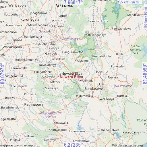
Nuwara Eliya GPS coordinates[2]
6° 58' 14.808" North, 80° 46' 58.296" East
| Map corner | latitude | longitude |
|---|---|---|
| Upper-left | 7.66817°, | 80.07974° |
| Center: | 6.97078°, | 80.78286° |
| Lower-right: | 6.27235°, | 81.48599° |
| Map W x H: | 155.2×155.2 km | = 96.4×96.4mi |
| max Lat: | 9.81667° ⇑47.4% North |
| Nuwara Eliya: | 6.97078° |
| min Lat: | ⇓52.6% South 5.92825° |
| min Long | Nuwara Eliya | max Long |
| 79.79528° | 80.78286° | 81.83472° |
| W 80.3%⇐ | ⇒19.7% E |
Elevation
Elevation of Nuwara Eliya is 1868 m = 6129 ft, and this is 1710.6 m = 5612 ft above average elevation for this country.
| Max E: |
1868 m = 6129 ft | 0% |
| Nuwara Eliya | 1868 m 6129 ft | |
| Avg. | 157.4 m = 516 ft | |
Min E: |
1 m = 3 ft | 100% |
See also: Sri Lanka elevation on elevation.city.
Geographical zone
Nuwara Eliya is located in North Torrid zone (between Equator and Tropic of Cancer). Distance of Equator is 775.1 km =481.6 mi to South.| Distance of | km | miles | from Nuwara Eliya |
|---|---|---|---|
| North Pole | 9232 | 5736.5 | to North |
| Arctic Circle | 6626.1 | 4117.3 | to North |
| Tropic Cancer | 1830.8 | 1137.6 | to North |
| Equator | 775.1 | 481.6 | to South |


Nearby cities:
15 places around Nuwara Eliya: (largest is in red/bold)
• Badulla
30.4 km =18.9 mi,  88°
88°
• Ella Town
30.9 km =19.2 mi,  109°
109°
• Gampola
31.9 km =19.8 mi,  312°
312°
• Hanwella Ihala
77.4 km =48.1 mi,  264°
264°
• Haputale
29.4 km =18.3 mi,  140°
140°
• Hatton
22.5 km =14 mi,  246°
246°
• Kadugannawa
42.6 km =26.5 mi,  317°
317°
• Kandy
39.2 km =24.4 mi,  335°
335°
• Kegalle
57.7 km =35.9 mi,  302°
302°
• Kurunegala
73.1 km =45.4 mi, 321°
• Matale
58.3 km =36.2 mi, 342°
• Monaragala
63.4 km =39.4 mi,  100°
100°
• Ratnapura
52.5 km =32.6 mi,  232°
232°
• Talawakele
14.3 km =8.9 mi, 254°
• Wellawaya
43.9 km =27.3 mi,  126°
126°
Sources, notices
• [Note1] Compared only with cities in Sri Lanka existing in our database
• [Src1] Map data: © OpenStreetMap contributors (CC-BY-SA)
• [Src2] Other city data from geonames.org with taken over terms of usage.
• [Src3] Geographical zone / Annual Mean Temperature by Robert A. Rohde @ Wikipedia
