Talawakele geodata
Talawakele (Central) is a populated place; located in Sri Lanka in Asia/Colombo (GMT+5.5) time zone. With population of 3,545 people, there are 69 cities with bigger population in this country. Compared to other cities in Sri Lanka, 51.3% of cities are located further ↑North; 76.3% of cities are located further ←West and 96.1% of cities have lower elevation than Talawakele. Note1
Administrative division(s):
- Level 1: Central
- Level 2: Nuwara Eliya District
- Level 3: Nuwara Eliya Division
- Level 4: Thalawakele


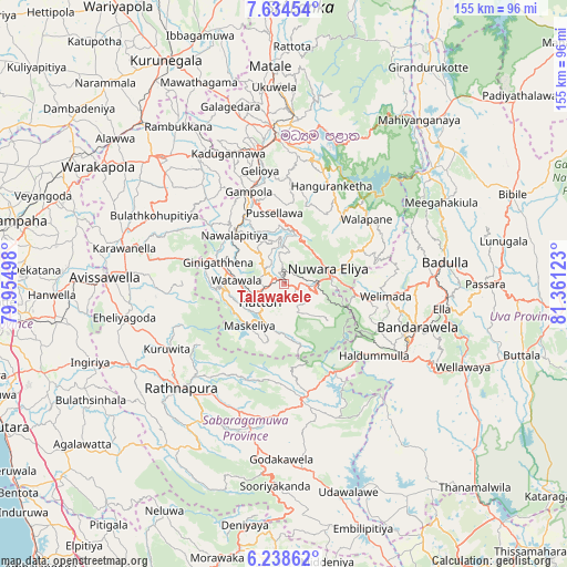
Talawakele GPS coordinates[2]
6° 56' 13.56" North, 80° 39' 29.16" East
| Map corner | latitude | longitude |
|---|---|---|
| Upper-left | 7.63454°, | 79.95498° |
| Center: | 6.9371°, | 80.6581° |
| Lower-right: | 6.23862°, | 81.36123° |
| Map W x H: | 155.2×155.2 km | = 96.4×96.4mi |
| max Lat: | 9.81667° ⇑51.3% North |
| Talawakele: | 6.9371° |
| min Lat: | ⇓48.7% South 5.92825° |
| min Long | Talawakele | max Long |
| 79.79528° | 80.6581° | 81.83472° |
| W 76.3%⇐ | ⇒23.7% E |
Elevation
Elevation of Talawakele is 1217 m = 3993 ft, and this is 1059.6 m = 3476 ft above average elevation for this country.
| Max E: |
1868 m = 6129 ft | 3.9% |
| Talawakele | 1217 m 3993 ft | |
| Avg. | 157.4 m = 516 ft | |
Min E: |
1 m = 3 ft | 96.1% |
See also: Sri Lanka elevation on elevation.city.
Geographical zone
Talawakele is located in North Torrid zone (between Equator and Tropic of Cancer). Distance of Equator is 771.3 km =479.3 mi to South.| Distance of | km | miles | from Talawakele |
|---|---|---|---|
| North Pole | 9235.7 | 5738.8 | to North |
| Arctic Circle | 6629.8 | 4119.6 | to North |
| Tropic Cancer | 1834.6 | 1140 | to North |
| Equator | 771.3 | 479.3 | to South |


Nearby cities:
15 places around Talawakele: (largest is in red/bold)
• Badulla
44.4 km =27.6 mi,  83°
83°
• Ella Town
43.4 km =27 mi,  99°
99°
• Gampola
27.1 km =16.8 mi,  338°
338°
• Hanwella Ihala
63.4 km =39.4 mi,  266°
266°
• Haputale
37.5 km =23.3 mi,  120°
120°
• Hatton
8.6 km =5.3 mi,  233°
233°
• Horana South
70.2 km =43.6 mi,  249°
249°
• Kadugannawa
38.3 km =23.8 mi, 337°
• Kandy
39.4 km =24.5 mi,  356°
356°
• Kegalle
49.3 km =30.6 mi,  315°
315°
• Kurunegala
68.7 km =42.7 mi,  332°
332°
• Matale
59.4 km =36.9 mi, 356°
• Nuwara Eliya
14.3 km =8.9 mi,  74°
74°
• Ratnapura
39.6 km =24.6 mi, 225°
• Wellawaya
53.9 km =33.5 mi,  114°
114°
Sources, notices
• [Note1] Compared only with cities in Sri Lanka existing in our database
• [Src1] Map data: © OpenStreetMap contributors (CC-BY-SA)
• [Src2] Other city data from geonames.org with taken over terms of usage.
• [Src3] Geographical zone / Annual Mean Temperature by Robert A. Rohde @ Wikipedia
