Devinuwara geodata
Devinuwara (Southern) is a populated place; located in Sri Lanka in Asia/Colombo (GMT+5.5) time zone. With population of 45,000 people, there are 27 cities with bigger population in this country. Compared to other cities in Sri Lanka, 100% of cities are located further ↑North; 69.7% of cities are located further ←West and 93.4% of cities have higher elevation than Devinuwara. Note1


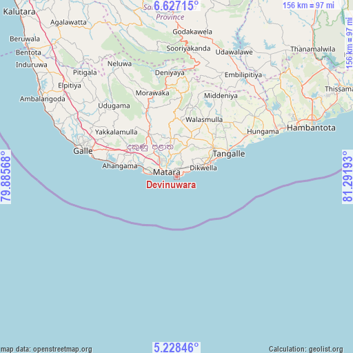
Devinuwara GPS coordinates[2]
5° 55' 41.7" North, 80° 35' 19.68" East
| Map corner | latitude | longitude |
|---|---|---|
| Upper-left | 6.62715°, | 79.88568° |
| Center: | 5.92825°, | 80.5888° |
| Lower-right: | 5.22846°, | 81.29193° |
| Map W x H: | 155.5×155.5 km | = 96.6×96.6mi |
| max Lat: | 9.81667° ⇑100% North |
| Devinuwara: | 5.92825° |
| min Lat: | ⇓0% South 5.92825° |
| min Long | Devinuwara | max Long |
| 79.79528° | 80.5888° | 81.83472° |
| W 69.7%⇐ | ⇒30.3% E |
Elevation
Elevation of Devinuwara is 6 m = 20 ft, and this is 151.4 m = 497 ft below average elevation for this country.
| Max E: |
1868 m = 6129 ft | 93.4% |
| Avg. | 157.4 m = 516 ft | |
| Devinuwara | 6 m = 20 ft | |
Min E: |
1 m = 3 ft | 6.6% |
See also: Devinuwara elevation on elevation.city.
Geographical zone
Devinuwara is located in North Torrid zone (between Equator and Tropic of Cancer). Distance of Equator is 659.2 km =409.6 mi to South.| Distance of | km | miles | from Devinuwara |
|---|---|---|---|
| North Pole | 9347.9 | 5808.5 | to North |
| Arctic Circle | 6742 | 4189.3 | to North |
| Tropic Cancer | 1946.8 | 1209.7 | to North |
| Equator | 659.2 | 409.6 | to South |


Nearby cities:
15 places around Devinuwara: (largest is in red/bold)
• Ambalangoda
68.3 km =42.4 mi,  300°
300°
• Bentota
85.8 km =53.3 mi,  310°
310°
• Beruwala
90.7 km =56.4 mi, 312°
• Galle
43.9 km =27.3 mi,  287°
287°
• Hikkaduwa
58.9 km =36.6 mi, 293°
• Horawala Junction
79.9 km =49.6 mi,  320°
320°
• Kataragama
98.5 km =61.2 mi,  56°
56°
• Koggala
29.5 km =18.3 mi,  283°
283°
• Matara
6.3 km =3.9 mi, 290°
• Mirissa city
14.6 km =9.1 mi, 278°
• Ratnapura
86.7 km =53.9 mi,  346°
346°
• Talpe
35.2 km =21.9 mi, 283°
• Tangalle
25.4 km =15.8 mi,  65°
65°
• Unawatuna
38.8 km =24.1 mi, 285°
• Weligama
18.3 km =11.4 mi, 286°
Sources, notices
• [Note1] Compared only with cities in Sri Lanka existing in our database
• [Src1] Map data: © OpenStreetMap contributors (CC-BY-SA)
• [Src2] Other city data from geonames.org with taken over terms of usage.
• [Src3] Geographical zone / Annual Mean Temperature by Robert A. Rohde @ Wikipedia
