Obeliai geodata
Obeliai (Panevėžys) is a populated place; located in Lithuania in Europe/Vilnius (GMT+3) time zone. With population of 1,247 people, there are 114 cities with bigger population in this country. Compared to other cities in Lithuania, 84.3% of cities are located further ↓South; 79.1% of cities are located further ←West and 54.5% of cities have lower elevation than Obeliai. Note1


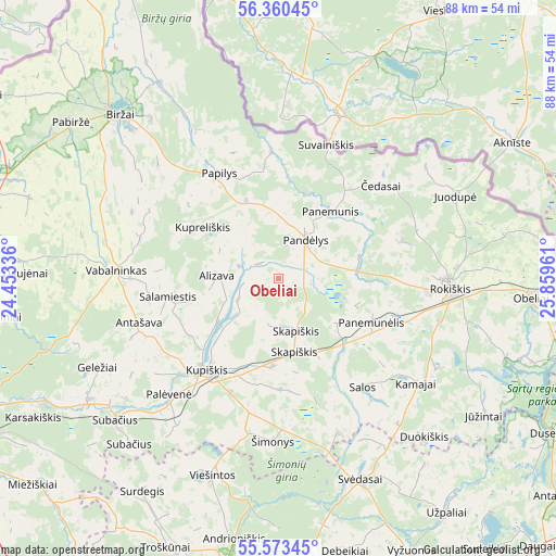
Obeliai GPS coordinates[2]
55° 58' 8.22" North, 25° 9' 23.328" East
| Map corner | latitude | longitude |
|---|---|---|
| Upper-left | 56.36045°, | 24.45336° |
| Center: | 55.96895°, | 25.15648° |
| Lower-right: | 55.57345°, | 25.85961° |
| Map W x H: | 87.5×87.5 km | = 54.4×54.4mi |
| max Lat: | 56.36149° ⇑15.7% North |
| Obeliai: | 55.96895° |
| min Lat: | ⇓84.3% South 54.01573° |
| min Long | Obeliai | max Long |
| 20.99651° | 25.15648° | 26.43984° |
| W 79.1%⇐ | ⇒20.9% E |
Elevation
Elevation of Obeliai is 91 m = 299 ft, and this is 0.3 m = 1 ft above average elevation for this country.
| Max E: |
204 m = 669 ft | 45.5% |
| Obeliai | 91 m 299 ft | |
| Avg. | 90.7 m = 298 ft | |
Min E: |
-1 m = -3 ft | 54.5% |
See also: Lithuania elevation on elevation.city.
Geographical zone
Obeliai is located in North temperate zone (between Tropic of Cancer and the Arctic Circle). Distance of this North polar circle is 1178 km =732 mi to North.| Distance of | km | miles | from Obeliai |
|---|---|---|---|
| North Pole | 3783.9 | 2351.2 | to North |
| Arctic Circle | 1178 | 732 | to North |
| Tropic Cancer | 3617.2 | 2247.6 | to South |
| Equator | 6223.2 | 3866.9 | to South |


Nearby cities:
15 places around Obeliai: (largest is in red/bold)
• Anyksciai
49.4 km =30.7 mi,  183°
183°
• Birzai
36 km =22.4 mi,  315°
315°
• Dusetos
49.6 km =30.8 mi,  119°
119°
• Juodupė
30.9 km =19.2 mi,  64°
64°
• Kavarskas
61.2 km =38 mi,  193°
193°
• Kupiskis
18.1 km =11.2 mi,  217°
217°
• Naujamiestis
70 km =43.5 mi,  243°
243°
• Pandėlys
7.7 km =4.8 mi,  34°
34°
• Panevėžys
56.7 km =35.2 mi, 242°
• Pasvalys
47.9 km =29.8 mi,  282°
282°
• Ramygala
73.7 km =45.8 mi,  226°
226°
• Rokiškis
27.3 km =17 mi,  92°
92°
• Utena
59.3 km =36.8 mi,  152°
152°
• Vabalninkas
25.4 km =15.8 mi,  273°
273°
• Zarasai
73.2 km =45.5 mi,  111°
111°
Sources, notices
• [Note1] Compared only with cities in Lithuania existing in our database
• [Src1] Map data: © OpenStreetMap contributors (CC-BY-SA)
• [Src2] Other city data from geonames.org with taken over terms of usage.
• [Src3] Geographical zone / Annual Mean Temperature by Robert A. Rohde @ Wikipedia
