Dūkštas geodata
Dūkštas (Utena) is a populated place; located in Lithuania in Europe/Vilnius (GMT+3) time zone. With population of 1,021 people, there are 121 cities with bigger population in this country. Compared to other cities in Lithuania, 66.4% of cities are located further ↓South; 99.3% of cities are located further ←West and 93.3% of cities have lower elevation than Dūkštas. Note1


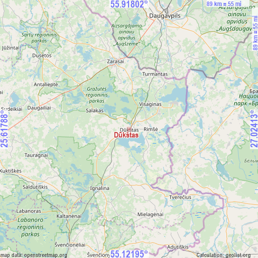
Dūkštas GPS coordinates[2]
55° 31' 19.2" North, 26° 19' 15.6" East
| Map corner | latitude | longitude |
|---|---|---|
| Upper-left | 55.91802°, | 25.61788° |
| Center: | 55.522°, | 26.321° |
| Lower-right: | 55.12195°, | 27.02413° |
| Map W x H: | 88.5×88.5 km | = 55×55mi |
| max Lat: | 56.36149° ⇑33.6% North |
| Dūkštas: | 55.522° |
| min Lat: | ⇓66.4% South 54.01573° |
| min Long | Dūkštas | max Long |
| 20.99651° | 26.321° | 26.43984° |
| W 99.3%⇐ | ⇒0.7% E |
Elevation
Elevation of Dūkštas is 165 m = 541 ft, and this is 74.3 m = 244 ft above average elevation for this country.
| Max E: |
204 m = 669 ft | 6.7% |
| Dūkštas | 165 m 541 ft | |
| Avg. | 90.7 m = 298 ft | |
Min E: |
-1 m = -3 ft | 93.3% |
See also: Lithuania elevation on elevation.city.
Geographical zone
Dūkštas is located in North temperate zone (between Tropic of Cancer and the Arctic Circle). Distance of this North polar circle is 1227.7 km =762.9 mi to North.| Distance of | km | miles | from Dūkštas |
|---|---|---|---|
| North Pole | 3833.6 | 2382.1 | to North |
| Arctic Circle | 1227.7 | 762.9 | to North |
| Tropic Cancer | 3567.5 | 2216.7 | to South |
| Equator | 6173.5 | 3836 | to South |


Nearby cities:
15 places around Dūkštas: (largest is in red/bold)
• Anyksciai
76.7 km =47.7 mi,  270°
270°
• Dusetos
38.9 km =24.2 mi,  309°
309°
• Ignalina
22.6 km =14 mi,  206°
206°
• Juodupė
77.1 km =47.9 mi,  324°
324°
• Kavarskas
88.3 km =54.9 mi,  263°
263°
• Molėtai
66 km =41 mi,  239°
239°
• Obeliai
88.2 km =54.8 mi,  304°
304°
• Pabradė
69.8 km =43.4 mi, 210°
• Pandėlys
88.5 km =55 mi, 309°
• Rokiškis
66.5 km =41.3 mi, 316°
• Utena
45.5 km =28.3 mi, 266°
• Visaginas
11.2 km =7 mi,  41°
41°
• Zarasai
23.8 km =14.8 mi,  349°
349°
• Švenčionys
44.2 km =27.5 mi,  193°
193°
• Švenčionėliai
44.9 km =27.9 mi, 206°
Sources, notices
• [Note1] Compared only with cities in Lithuania existing in our database
• [Src1] Map data: © OpenStreetMap contributors (CC-BY-SA)
• [Src2] Other city data from geonames.org with taken over terms of usage.
• [Src3] Geographical zone / Annual Mean Temperature by Robert A. Rohde @ Wikipedia
