Dusetos geodata
Dusetos (Utena) is a populated place; located in Lithuania in Europe/Vilnius (GMT+3) time zone. With population of 833 people, there are 125 cities with bigger population in this country. Compared to other cities in Lithuania, 76.9% of cities are located further ↓South; 95.5% of cities are located further ←West and 64.9% of cities have lower elevation than Dusetos. Note1


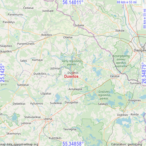
Dusetos GPS coordinates[2]
55° 44' 46.86" North, 25° 50' 44.232" East
| Map corner | latitude | longitude |
|---|---|---|
| Upper-left | 56.14011°, | 25.1425° |
| Center: | 55.74635°, | 25.84562° |
| Lower-right: | 55.34858°, | 26.54875° |
| Map W x H: | 88×88 km | = 54.7×54.7mi |
| max Lat: | 56.36149° ⇑23.1% North |
| Dusetos: | 55.74635° |
| min Lat: | ⇓76.9% South 54.01573° |
| min Long | Dusetos | max Long |
| 20.99651° | 25.84562° | 26.43984° |
| W 95.5%⇐ | ⇒4.5% E |
Elevation
Elevation of Dusetos is 108 m = 354 ft, and this is 17.3 m = 57 ft above average elevation for this country.
| Max E: |
204 m = 669 ft | 35.1% |
| Dusetos | 108 m 354 ft | |
| Avg. | 90.7 m = 298 ft | |
Min E: |
-1 m = -3 ft | 64.9% |
See also: Lithuania elevation on elevation.city.
Geographical zone
Dusetos is located in North temperate zone (between Tropic of Cancer and the Arctic Circle). Distance of this North polar circle is 1202.8 km =747.4 mi to North.| Distance of | km | miles | from Dusetos |
|---|---|---|---|
| North Pole | 3808.6 | 2366.6 | to North |
| Arctic Circle | 1202.8 | 747.4 | to North |
| Tropic Cancer | 3592.5 | 2232.3 | to South |
| Equator | 6198.4 | 3851.5 | to South |


Nearby cities:
15 places around Dusetos: (largest is in red/bold)
• Anyksciai
52.7 km =32.7 mi,  242°
242°
• Dūkštas
38.9 km =24.2 mi,  129°
129°
• Ignalina
49.3 km =30.6 mi,  156°
156°
• Juodupė
40.7 km =25.3 mi,  338°
338°
• Kavarskas
67.3 km =41.8 mi, 238°
• Kupiskis
55.1 km =34.2 mi,  280°
280°
• Molėtai
64 km =39.8 mi,  204°
204°
• Obeliai
49.6 km =30.8 mi,  299°
299°
• Pandėlys
49.6 km =30.8 mi,  308°
308°
• Rokiškis
28.3 km =17.6 mi,  326°
326°
• Utena
31.7 km =19.7 mi,  209°
209°
• Visaginas
40.8 km =25.4 mi,  114°
114°
• Zarasai
25.4 km =15.8 mi,  93°
93°
• Švenčionys
70.8 km =44 mi, 163°
• Švenčionėliai
65.8 km =40.9 mi,  171°
171°
Sources, notices
• [Note1] Compared only with cities in Lithuania existing in our database
• [Src1] Map data: © OpenStreetMap contributors (CC-BY-SA)
• [Src2] Other city data from geonames.org with taken over terms of usage.
• [Src3] Geographical zone / Annual Mean Temperature by Robert A. Rohde @ Wikipedia
