Kupiskis geodata
Kupiskis (Panevėžys) is a seat of a second-order administrative division; located in Lithuania in Europe/Vilnius (GMT+3) time zone. With population of 8,263 people, there are 53 cities with bigger population in this country. Compared to other cities in Lithuania, 79.9% of cities are located further ↓South; 74.6% of cities are located further ←West and 57.5% of cities have lower elevation than Kupiskis. Note1


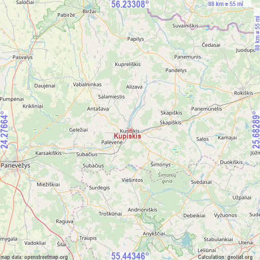
Kupiskis GPS coordinates[2]
55° 50' 24.972" North, 24° 58' 47.136" East
| Map corner | latitude | longitude |
|---|---|---|
| Upper-left | 56.23308°, | 24.27664° |
| Center: | 55.84027°, | 24.97976° |
| Lower-right: | 55.44346°, | 25.68289° |
| Map W x H: | 87.8×87.8 km | = 54.6×54.6mi |
| max Lat: | 56.36149° ⇑20.1% North |
| Kupiskis: | 55.84027° |
| min Lat: | ⇓79.9% South 54.01573° |
| min Long | Kupiskis | max Long |
| 20.99651° | 24.97976° | 26.43984° |
| W 74.6%⇐ | ⇒25.4% E |
Elevation
Elevation of Kupiskis is 97 m = 318 ft, and this is 6.3 m = 21 ft above average elevation for this country.
| Max E: |
204 m = 669 ft | 42.5% |
| Kupiskis | 97 m 318 ft | |
| Avg. | 90.7 m = 298 ft | |
Min E: |
-1 m = -3 ft | 57.5% |
See also: Lithuania elevation on elevation.city.
Geographical zone
Kupiskis is located in North temperate zone (between Tropic of Cancer and the Arctic Circle). Distance of this North polar circle is 1192.3 km =740.9 mi to North.| Distance of | km | miles | from Kupiskis |
|---|---|---|---|
| North Pole | 3798.2 | 2360.1 | to North |
| Arctic Circle | 1192.3 | 740.9 | to North |
| Tropic Cancer | 3602.9 | 2238.7 | to South |
| Equator | 6208.9 | 3858 | to South |


Nearby cities:
15 places around Kupiskis: (largest is in red/bold)
• Anyksciai
35.8 km =22.2 mi,  167°
167°
• Birzai
42.5 km =26.4 mi,  340°
340°
• Dusetos
55.1 km =34.2 mi,  100°
100°
• Juodupė
47.7 km =29.6 mi,  54°
54°
• Kavarskas
45.3 km =28.1 mi,  184°
184°
• Naujamiestis
54.4 km =33.8 mi,  251°
251°
• Obeliai
18.1 km =11.2 mi,  37°
37°
• Pandėlys
25.8 km =16 mi, 36°
• Panevėžys
41.1 km =25.5 mi, 253°
• Pasvalys
43.4 km =27 mi,  304°
304°
• Ramygala
56 km =34.8 mi,  229°
229°
• Rokiškis
40.5 km =25.2 mi,  71°
71°
• Ukmerge
67.2 km =41.8 mi,  192°
192°
• Utena
54.4 km =33.8 mi,  134°
134°
• Vabalninkas
21.3 km =13.2 mi,  317°
317°
Sources, notices
• [Note1] Compared only with cities in Lithuania existing in our database
• [Src1] Map data: © OpenStreetMap contributors (CC-BY-SA)
• [Src2] Other city data from geonames.org with taken over terms of usage.
• [Src3] Geographical zone / Annual Mean Temperature by Robert A. Rohde @ Wikipedia
