Mertert geodata
Mertert (Grevenmacher) is a seat of a third-order administrative division; located in Luxembourg in Europe/Luxembourg (GMT+2) time zone. With population of 1,163 people, there are 70 cities with bigger population in this country. Compared to other cities in Luxembourg, 61% of cities are located further ↓South; 98.9% of cities are located further ←West and 97.2% of cities have higher elevation than Mertert. Note1


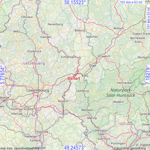
Mertert GPS coordinates[2]
49° 42' 9.396" North, 6° 28' 46.776" East
| Map corner | latitude | longitude |
|---|---|---|
| Upper-left | 50.15523°, | 5.77654° |
| Center: | 49.70261°, | 6.47966° |
| Lower-right: | 49.24573°, | 7.18279° |
| Map W x H: | 101.1×101.1 km | = 62.8×62.8mi |
| max Lat: | 50.13722° ⇑39% North |
| Mertert: | 49.70261° |
| min Lat: | ⇓61% South 49.45964° |
| min Long | Mertert | max Long |
| 5.76583° | 6.47966° | 6.50532° |
| W 98.9%⇐ | ⇒1.1% E |
Elevation
Elevation of Mertert is 148 m = 486 ft, and this is 134 m = 440 ft below average elevation for this country.
| Max E: |
502 m = 1647 ft | 97.2% |
| Avg. | 282 m = 925 ft | |
| Mertert | 148 m = 486 ft | |
Min E: |
143 m = 469 ft | 2.8% |
See also: Luxembourg elevation on elevation.city.
Geographical zone
Mertert is located in North temperate zone (between Tropic of Cancer and the Arctic Circle). Distance of this North polar circle is 1874.8 km =1164.9 mi to North.| Distance of | km | miles | from Mertert |
|---|---|---|---|
| North Pole | 4480.6 | 2784.1 | to North |
| Arctic Circle | 1874.8 | 1164.9 | to North |
| Tropic Cancer | 2920.5 | 1814.7 | to South |
| Equator | 5526.4 | 3433.9 | to South |


Nearby cities:
15 places around Mertert: (largest is in red/bold)
• Bech
10 km =6.2 mi,  303°
303°
• Berbourg
6.9 km =4.3 mi, 296°
• Betzdorf
9.6 km =6 mi,  257°
257°
• Biwer
7.8 km =4.8 mi,  272°
272°
• Echternach
12.9 km =8 mi,  340°
340°
• Ehnen
13.1 km =8.1 mi,  210°
210°
• Flaxweiler
10.6 km =6.6 mi,  247°
247°
• Grevenmacher
4 km =2.5 mi,  225°
225°
• Manternach
3.8 km =2.4 mi, 270°
• Mompach
5 km =3.1 mi,  347°
347°
• Rosport
11.5 km =7.1 mi,  9°
9°
• Steinheim
12.8 km =8 mi,  359°
359°
• Wasserbillig
2 km =1.2 mi,  43°
43°
• Wecker
6.8 km =4.2 mi, 262°
• Wormeldange
11.5 km =7.1 mi, 207°
Sources, notices
• [Note1] Compared only with cities in Luxembourg existing in our database
• [Src1] Map data: © OpenStreetMap contributors (CC-BY-SA)
• [Src2] Other city data from geonames.org with taken over terms of usage.
• [Src3] Geographical zone / Annual Mean Temperature by Robert A. Rohde @ Wikipedia
