Wasserbillig geodata
Wasserbillig (Grevenmacher) is a populated place; located in Luxembourg in Europe/Luxembourg (GMT+2) time zone. With population of 2,327 people, there are 35 cities with bigger population in this country. Compared to other cities in Luxembourg, 63.8% of cities are located further ↓South; 99.4% of cities are located further ←West and 99.4% of cities have higher elevation than Wasserbillig. Note1


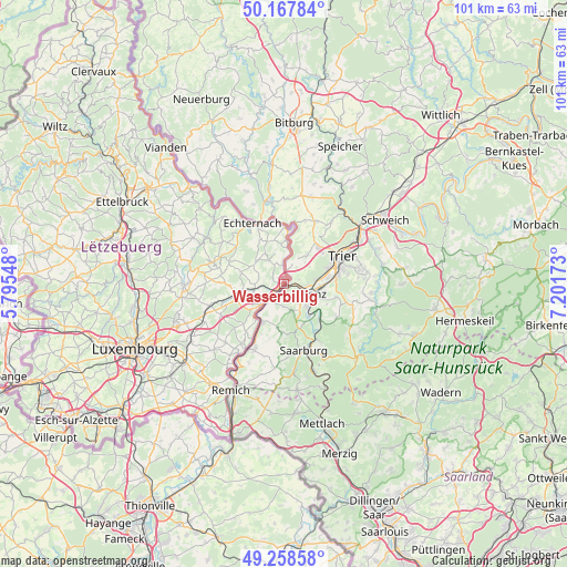
Wasserbillig GPS coordinates[2]
49° 42' 55.224" North, 6° 29' 54.996" East
| Map corner | latitude | longitude |
|---|---|---|
| Upper-left | 50.16784°, | 5.79548° |
| Center: | 49.71534°, | 6.49861° |
| Lower-right: | 49.25858°, | 7.20173° |
| Map W x H: | 101.1×101.1 km | = 62.8×62.8mi |
| max Lat: | 50.13722° ⇑36.2% North |
| Wasserbillig: | 49.71534° |
| min Lat: | ⇓63.8% South 49.45964° |
| min Long | Wasserbillig | max Long |
| 5.76583° | 6.49861° | 6.50532° |
| W 99.4%⇐ | ⇒0.59999999999999% E |
Elevation
Elevation of Wasserbillig is 144 m = 472 ft, and this is 138 m = 453 ft below average elevation for this country.
| Max E: |
502 m = 1647 ft | 99.4% |
| Avg. | 282 m = 925 ft | |
| Wasserbillig | 144 m = 472 ft | |
Min E: |
143 m = 469 ft | 0.6% |
See also: Luxembourg elevation on elevation.city.
Geographical zone
Wasserbillig is located in North temperate zone (between Tropic of Cancer and the Arctic Circle). Distance of this North polar circle is 1873.3 km =1164 mi to North.| Distance of | km | miles | from Wasserbillig |
|---|---|---|---|
| North Pole | 4479.2 | 2783.2 | to North |
| Arctic Circle | 1873.3 | 1164 | to North |
| Tropic Cancer | 2921.9 | 1815.6 | to South |
| Equator | 5527.8 | 3434.8 | to South |


Nearby cities:
15 places around Wasserbillig: (largest is in red/bold)
• Bech
10.5 km =6.5 mi,  293°
293°
• Berbourg
7.7 km =4.8 mi,  282°
282°
• Betzdorf
11.3 km =7 mi,  251°
251°
• Biwer
9.2 km =5.7 mi,  263°
263°
• Consdorf
13.5 km =8.4 mi,  302°
302°
• Echternach
12.2 km =7.6 mi,  331°
331°
• Flaxweiler
12.5 km =7.8 mi,  243°
243°
• Grevenmacher
5.9 km =3.7 mi,  224°
224°
• Manternach
5.4 km =3.4 mi, 254°
• Mertert
2 km =1.2 mi, 223°
• Mompach
4.2 km =2.6 mi,  324°
324°
• Rosport
9.9 km =6.2 mi,  2°
2°
• Steinheim
11.5 km =7.1 mi,  352°
352°
• Wecker
8.5 km =5.3 mi, 254°
• Wormeldange
13.4 km =8.3 mi,  210°
210°
Sources, notices
• [Note1] Compared only with cities in Luxembourg existing in our database
• [Src1] Map data: © OpenStreetMap contributors (CC-BY-SA)
• [Src2] Other city data from geonames.org with taken over terms of usage.
• [Src3] Geographical zone / Annual Mean Temperature by Robert A. Rohde @ Wikipedia
