Biwer geodata
Biwer (Grevenmacher) is a seat of a third-order administrative division; located in Luxembourg in Europe/Luxembourg (GMT+2) time zone. With population of 653 people, there are 124 cities with bigger population in this country. Compared to other cities in Luxembourg, 62.7% of cities are located further ↓South; 93.2% of cities are located further ←West and 76.8% of cities have higher elevation than Biwer. Note1


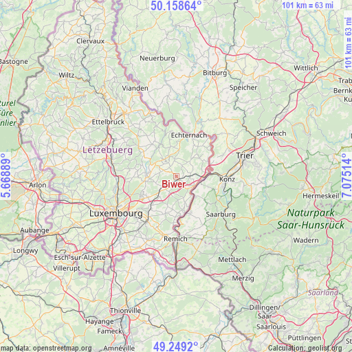
Biwer GPS coordinates[2]
49° 42' 21.78" North, 6° 22' 19.236" East
| Map corner | latitude | longitude |
|---|---|---|
| Upper-left | 50.15864°, | 5.66889° |
| Center: | 49.70605°, | 6.37201° |
| Lower-right: | 49.2492°, | 7.07514° |
| Map W x H: | 101.1×101.1 km | = 62.8×62.8mi |
| max Lat: | 50.13722° ⇑37.3% North |
| Biwer: | 49.70605° |
| min Lat: | ⇓62.7% South 49.45964° |
| min Long | Biwer | max Long |
| 5.76583° | 6.37201° | 6.50532° |
| W 93.2%⇐ | ⇒6.8% E |
Elevation
Elevation of Biwer is 232 m = 761 ft, and this is 50 m = 164 ft below average elevation for this country.
| Max E: |
502 m = 1647 ft | 76.8% |
| Avg. | 282 m = 925 ft | |
| Biwer | 232 m = 761 ft | |
Min E: |
143 m = 469 ft | 23.2% |
See also: Luxembourg elevation on elevation.city.
Geographical zone
Biwer is located in North temperate zone (between Tropic of Cancer and the Arctic Circle). Distance of this North polar circle is 1874.4 km =1164.7 mi to North.| Distance of | km | miles | from Biwer |
|---|---|---|---|
| North Pole | 4480.3 | 2783.9 | to North |
| Arctic Circle | 1874.4 | 1164.7 | to North |
| Tropic Cancer | 2920.9 | 1815 | to South |
| Equator | 5526.8 | 3434.2 | to South |


Nearby cities:
15 places around Biwer: (largest is in red/bold)
• Bech
5.2 km =3.2 mi,  353°
353°
• Berbourg
3.1 km =1.9 mi,  29°
29°
• Betzdorf
3 km =1.9 mi,  212°
212°
• Consdorf
8.6 km =5.3 mi,  344°
344°
• Flaxweiler
4.9 km =3 mi,  204°
204°
• Gonderange
9.2 km =5.7 mi,  262°
262°
• Grevenmacher
5.8 km =3.6 mi,  122°
122°
• Junglinster
8.6 km =5.3 mi,  270°
270°
• Manternach
3.9 km =2.4 mi,  95°
95°
• Mensdorf
7.5 km =4.7 mi,  220°
220°
• Mertert
7.8 km =4.8 mi,  92°
92°
• Mompach
8 km =5 mi,  56°
56°
• Roodt-sur-Syre
6.7 km =4.2 mi,  228°
228°
• Wasserbillig
9.2 km =5.7 mi,  83°
83°
• Wecker
1.6 km =1 mi,  142°
142°
Sources, notices
• [Note1] Compared only with cities in Luxembourg existing in our database
• [Src1] Map data: © OpenStreetMap contributors (CC-BY-SA)
• [Src2] Other city data from geonames.org with taken over terms of usage.
• [Src3] Geographical zone / Annual Mean Temperature by Robert A. Rohde @ Wikipedia
