Targuist geodata
Targuist (Tanger-Tetouan-Al Hoceima) is a seat of a third-order administrative division; located in Morocco in Africa/Casablanca (GMT+1) time zone. With population of 11,560 people, there are 88 cities with bigger population in this country. Compared to other cities in Morocco, 84.5% of cities are located further ↓South; 82.6% of cities are located further ←West and 77.9% of cities have lower elevation than Targuist. Note1
Administrative division(s):
- Level 1: Tanger-Tetouan-Al Hoceima
- Level 2: Al-Hoceima
- Level 3: Targuist


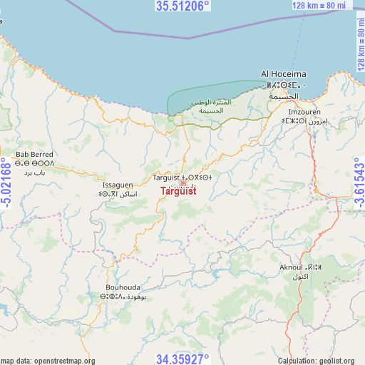
Targuist GPS coordinates[2]
34° 56' 15.684" North, 4° 19' 6.816" West
| Map corner | latitude | longitude |
|---|---|---|
| Upper-left | 35.51206°, | -5.02168° |
| Center: | 34.93769°, | -4.31856° |
| Lower-right: | 34.35927°, | -3.61543° |
| Map W x H: | 128.2×128.2 km | = 79.7×79.7mi |
| max Lat: | 35.84906° ⇑15.5% North |
| Targuist: | 34.93769° |
| min Lat: | ⇓84.5% South 22.6558° |
| min Long | Targuist | max Long |
| -15.60719° | -4.31856° | -1.22855° |
| W 82.6%⇐ | ⇒17.4% E |
Elevation
Elevation of Targuist is 1029 m = 3376 ft, and this is 412.2 m = 1352 ft above average elevation for this country.
| Max E: |
2637 m = 8652 ft | 22.1% |
| Targuist | 1029 m 3376 ft | |
| Avg. | 616.8 m = 2024 ft | |
Min E: |
1 m = 3 ft | 77.9% |
See also: Morocco elevation on elevation.city.
Geographical zone
Targuist is located in North temperate zone (between Tropic of Cancer and the Arctic Circle). Distance of this Northern Tropic circle is 1278.8 km =794.6 mi to South.| Distance of | km | miles | from Targuist |
|---|---|---|---|
| North Pole | 6122.4 | 3804.3 | to North |
| Arctic Circle | 3516.5 | 2185.1 | to North |
| Tropic Cancer | 1278.8 | 794.6 | to South |
| Equator | 3884.7 | 2413.8 | to South |


Nearby cities:
15 places around Targuist: (largest is in red/bold)
• Ajdir
38 km =23.6 mi,  124°
124°
• Aknoul
51.9 km =32.2 mi,  127°
127°
• Al Hoceïma
49.2 km =30.6 mi,  44°
44°
• Bni Bouayach
47.4 km =29.5 mi,  66°
66°
• Boudinar
67.8 km =42.1 mi, 69°
• Galaz
62.3 km =38.7 mi,  225°
225°
• Imzouren
48.5 km =30.1 mi,  61°
61°
• Oulad Daoud
68.5 km =42.6 mi,  210°
210°
• Ratba
59.4 km =36.9 mi,  252°
252°
• Rouadi
28.1 km =17.5 mi, 36°
• Senada
17.9 km =11.1 mi,  31°
31°
• Tamorot
42 km =26.1 mi,  269°
269°
• Taounate
53.4 km =33.2 mi, 213°
• Timezgana
54.7 km =34 mi,  223°
223°
• Tirhanimîne
46.9 km =29.1 mi, 44°
Sources, notices
• [Note1] Compared only with cities in Morocco existing in our database
• [Src1] Map data: © OpenStreetMap contributors (CC-BY-SA)
• [Src2] Other city data from geonames.org with taken over terms of usage.
• [Src3] Geographical zone / Annual Mean Temperature by Robert A. Rohde @ Wikipedia
